
Fail:Çankırı districts.png

Saiz pralihat ini: 776 × 600 piksel. Leraian-leraian lain: 311 × 240 piksel | 621 × 480 piksel | 994 × 768 piksel | 1,056 × 816 piksel.
Fail asli (1,056 × 816 piksel, saiz fail: 37 KB, jenis MIME: image/png)
Ringkasan
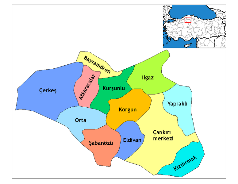
| Keterangan | Map of the districts of Çankırı province in Turkey. Created by Rarelibra 19:28, 1 December 2006 (UTC) for public domain use, using MapInfo Professional v8.5 and various mapping resources. Edited by One Homo Sapiens Corrected text where İ,Ş,ı,ğ,or ş occurs in name. Source: [statoids-com]. Increased font size and enhanced color differences among adjacent districts. |
| Tarikh | 31 Mac 2007 (original upload date) |
| Sumber | No machine-readable source provided. Own work assumed (based on copyright claims). |
| Pengarang | No machine-readable author provided. Denizz~commonswiki assumed (based on copyright claims). |
Perlesenan
| Saya selaku pemegang hak cipta karya ini melepaskan karya ini ke dalam domain awam di seluruh dunia. Di sesetengah negara, undang-undangnya mungkin tidak mengizinkan; jika begitu: Saya memberi sesiapa sahaja hak untuk menggunakan karya ini untuk apa jua tujuan, tanpa sebarang syarat, melainkan undang-undang menetapkan syarat-syarat sedemikian. |
Sejarah fail
Klik pada tarikh/waktu untuk melihat rupa fail tersebut pada waktu itu.
| Tarikh/Waktu | Gambar kenit | Ukuran | Pengguna | Komen | |
|---|---|---|---|---|---|
| semasa | 21:46, 28 Disember 2008 | | 1,056 × 816 (37 KB) | One Homo Sapiens | Corrected text where İ,Ş,ı,ğ,or ş occurs in name. Source: [statoids-com]. Increased font size and enhanced color differences among adjacent districts. |
| 07:14, 31 Mac 2007 |  | 1,056 × 816 (30 KB) | Denizz~commonswiki | == Summary == Map of the districts of Cankiri province in Turkey. Created by Rarelibra 19:28, 1 December 2006 (UTC) for public domain use, using MapInfo Professional v8.5 and various mapping resources. == Licensing == {{PD-self}} <!-- |
Penggunaan fail
13 buah laman berikut menggunakan fail ini:
Penggunaan fail sejagat
Fail ini digunakan oleh wiki-wiki lain yang berikut:
- Penggunaan di ast.wikipedia.org
- Penggunaan di ba.wikipedia.org
- Penggunaan di ca.wikipedia.org
- Penggunaan di cs.wikipedia.org
- Penggunaan di de.wikipedia.org
- Penggunaan di diq.wikipedia.org
- Penggunaan di en.wikipedia.org
- Çankırı Province
- Wikipedia:Reference desk/Archives/Science/2009 December 25
- Districts of Turkey
- Governor of Çankırı
- List of populated places in Çankırı Province
- Orta District
- Atkaracalar District
- Bayramören District
- Çankırı District
- Çerkeş District
- Eldivan District
- Ilgaz District
- Kızılırmak District
- Korgun District
- Kurşunlu District
- Şabanözü District
- Yapraklı District
- Penggunaan di eo.wikipedia.org
- Penggunaan di es.wikipedia.org
- Penggunaan di eu.wikipedia.org
- Penggunaan di fa.wikipedia.org
Lihat banyak lagi penggunaan sejagat bagi fail ini.