
Fail:Daedelus comparison, remote sensing in precision farming.jpg
Saiz pralihat ini: 366 × 598 piksel. Leraian-leraian lain: 147 × 240 piksel | 540 × 883 piksel.
Fail asli (540 × 883 piksel, saiz fail: 143 KB, jenis MIME: image/jpeg)
| Keterangan |
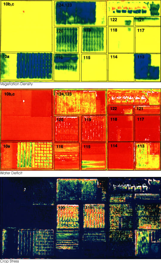
English: These three false-color images demonstrate some of the applications of remote sensing in precision farming. The goal of precision farming is to improve farmers’ profits and harvest yields while reducing the negative impacts of farming on the environment that come from over-application of chemicals. The images were acquired by the Daedalus sensor aboard a NASA aircraft flying over the Maricopa Agricultural Center in Arizona.
|
|||||
| Tarikh | before 30 Januari 2001 | |||||
| Sumber | earthobservatory.nasa.gov (NASA Earth Observatory, Image of the Day 2001-01-30 "Precision Farming") | |||||
| Pengarang | Susan Moran, Landsat 7 Science Team and USDA Agricultural Research Service (U.S. Government work) | |||||
| Kebenaran (Penggunaan semula fail ini) |
|
|||||
| Versi lain |
.jpg) |

Sejarah fail
Klik pada tarikh/waktu untuk melihat rupa fail tersebut pada waktu itu.
| Tarikh/Waktu | Gambar kenit | Ukuran | Pengguna | Komen | |
|---|---|---|---|---|---|
| semasa | 01:10, 28 Jun 2010 | | 540 × 883 (143 KB) | Bdk | {{Information |Description={{en|These three false-color images demonstrate some of the applications of remote sensing in precision farming. The goal of precision farming is to improve farmers’ profits and harvest yields whi |
Penggunaan fail
2 buah laman berikut menggunakan fail ini:
Penggunaan fail sejagat
Fail ini digunakan oleh wiki-wiki lain yang berikut:
- Penggunaan di ar.wikipedia.org
- Penggunaan di en.wikipedia.org
- Penggunaan di en.wikiversity.org
- Penggunaan di eu.wikipedia.org
- Penggunaan di fr.wikipedia.org
- Penggunaan di id.wikipedia.org
- Penggunaan di it.wikipedia.org
- Penggunaan di ja.wikipedia.org
- Penggunaan di ko.wikipedia.org
- Penggunaan di oc.wikipedia.org
- Penggunaan di ru.wikipedia.org
- Penggunaan di ta.wikipedia.org
- Penggunaan di uk.wikipedia.org
- Penggunaan di www.wikidata.org