
Fail:Mediterranean Relief.jpg
Saiz pralihat ini: 800 × 448 piksel. Leraian-leraian lain: 320 × 179 piksel | 640 × 359 piksel | 1,308 × 733 piksel.
Fail asli (1,308 × 733 piksel, saiz fail: 635 KB, jenis MIME: image/jpeg)

|
This map image could be re-created using vector graphics as an SVG file. This has several advantages; see Commons:Media for cleanup for more information. If an SVG form of this image is available, please upload it and afterwards replace this template with
{{vector version available|new image name}}.
It is recommended to name the SVG file “Mediterranean Relief.svg”—then the template Vector version available (or Vva) does not need the new image name parameter. |


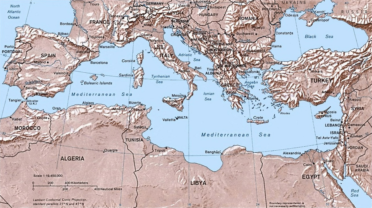
- Shaded relief Map of the Mediterranean Sea - and its Basin and Landforms.
- The original map was created in 1982 by the Central Intelligence Agency ([1], specifically [2]).
- This version was produced by w:User:Joy, who originally uploaded it to the English Wikipedia:
- 23:46, 28 Sep 2004 . . Joy (343433 bytes) (an update after 22 years :) added borders and names for the ex-yu republics (si,hr,ba,cs,mk); corrected names for de,sk; dropped su name but didn't bother drawing the md/uk/ru borders or names because they're not near the topic at hand, and it's tiresome)
![[2]](http://www.lib.utexas.edu/maps/europe/mediterranean_rel82.jpg)
This work is in the public domain in the United States because it is a work prepared by an officer or employee of the United States Government as part of that person’s official duties under the terms of Title 17, Chapter 1, Section 105 of the US Code.
Note: This only applies to original works of the Federal Government and not to the work of any individual U.S. state, territory, commonwealth, county, municipality, or any other subdivision. This template also does not apply to postage stamp designs published by the United States Postal Service since 1978. (See § 313.6(C)(1) of Compendium of U.S. Copyright Office Practices). It also does not apply to certain US coins; see The US Mint Terms of Use.
|
 | |
| Fail ini telah dikenal pasti sebagai bebas daripada sekatan-sekatan yang dikenali mengikut undang-undang hak cipta, termasuk semua hak berkaitan dan berjiran. | ||
Sejarah fail
Klik pada tarikh/waktu untuk melihat rupa fail tersebut pada waktu itu.
| Tarikh/Waktu | Gambar kenit | Ukuran | Pengguna | Komen | |
|---|---|---|---|---|---|
| semasa | 14:32, 6 Mei 2016 | | 1,308 × 733 (635 KB) | Julieta39 | Actualised the borders |
| 21:38, 30 Mei 2015 |  | 1,308 × 733 (614 KB) | Subtropical-man | Reverted to version as of 18:25, 29 August 2011 | |
| 00:59, 1 September 2011 |  | 1,428 × 800 (400 KB) | Gwillhickers | Larger image, better sharpness | |
| 00:58, 1 September 2011 |  | 1,428 × 800 (400 KB) | Gwillhickers | Larger ima | |
| 18:25, 29 Ogos 2011 |  | 1,308 × 733 (614 KB) | Subtropical-man | ||
| 22:21, 24 Ogos 2011 |  | 1,428 × 800 (400 KB) | Gwillhickers | better sharpness, color tone | |
| 01:01, 27 Jun 2010 |  | 1,308 × 733 (614 KB) | Ras67 | rotated and cropped | |
| 20:22, 4 Jun 2010 |  | 1,325 × 739 (288 KB) | Cropbot | upload cropped version, operated by User:diaa_abdelmoneim. Summary: cropped | |
| 19:22, 21 Disember 2005 |  | 1,332 × 792 (274 KB) | Lhgodoy~commonswiki | Noise removal in original image | |
| 20:59, 4 Disember 2004 |  | 1,332 × 792 (335 KB) | Alfio | Map of the Mediterranean Sea |
Penggunaan fail
Laman berikut menggunakan fail ini:
Penggunaan fail sejagat
Fail ini digunakan oleh wiki-wiki lain yang berikut:
- Penggunaan di af.wikipedia.org
- Penggunaan di am.wikipedia.org
- Penggunaan di arc.wikipedia.org
- Penggunaan di ar.wikipedia.org
- Penggunaan di arz.wikipedia.org
- Penggunaan di ast.wikipedia.org
- Penggunaan di as.wikipedia.org
- Penggunaan di az.wikipedia.org
- Penggunaan di az.wiktionary.org
- Penggunaan di be.wikipedia.org
- Penggunaan di bo.wikipedia.org
- Penggunaan di bs.wikipedia.org
- Penggunaan di ca.wikipedia.org
- Penggunaan di ceb.wikipedia.org
- Penggunaan di cv.wikipedia.org
- Penggunaan di cy.wikipedia.org
- Penggunaan di da.wikipedia.org
- Penggunaan di de.wikipedia.org
- Penggunaan di dsb.wikipedia.org
- Penggunaan di dty.wikipedia.org
- Penggunaan di el.wikipedia.org
- Penggunaan di en.wikipedia.org
- Penggunaan di en.wiktionary.org
- Penggunaan di eo.wikipedia.org
- Penggunaan di es.wikipedia.org
Lihat banyak lagi penggunaan sejagat bagi fail ini.