
Fail:NZTerritorialAuthorities.png
Saiz pralihat ini: 458 × 600 piksel. Leraian-leraian lain: 183 × 240 piksel | 366 × 480 piksel | 872 × 1,142 piksel.
Fail asli (872 × 1,142 piksel, saiz fail: 68 KB, jenis MIME: image/png)
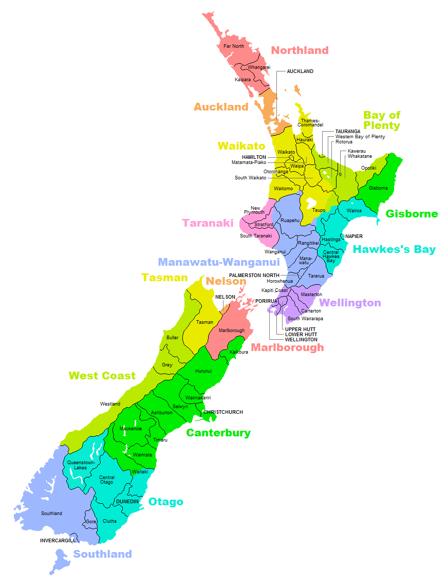
Ringkasan
| Keterangan |
English: Map of territorial authorities (regions, districts, municipalities, etc) in New Zealand |
| Tarikh | |
| Sumber | Karya sendiri |
| Pengarang | Vardion |
| Versi lain | Derivative works of this file: NZTerritorialAuthorities-Waikato.png |
Perlesenan
Dengan ini, saya selaku pemegang hak cipta karya ini, menerbitkannya di bawah lesen-lesen yang berikut:

|
Kebenaran diberikan untuk menyalin, mengedar dan/atau mengubah dokumen ini di bawah syarat-syarat Lesen Pendokumenan Bebas GNU, versi 1.2 atau mana-mana versi selepas ini, yang diterbitkan oleh Yayasan Perisian Bebas; tanpa Seksyen yang Tak Berubah, tanpa Teks Kulit Depan dan tanpa Teks Kulit Belakang. Salinan lesen ini boleh didapati dalam seksyen yang bertajuk Lesen Pendokumenan Bebas GNU". |
Fail ini dilesenkan di bawah lesen Pengiktirafan-Perkongsian Serupa 3.0 Tidak Diport, 2.5 Umum, 2.0 Umum dan 1.0 Umum Creative Commons.
- Anda bebas:
- untuk berkongsi – untuk menyalin, mengedar dan memindah hasil kerja
- untuk mencampur semula – untuk menyesuaikan karya
- Di bawah syarat berikut:
- pengiktirafan – Anda mesti memberi penghargaan yang berpatutan, bekalkan pautan ke lesen, dan tunjukkan jika perubahan telah dibuat. Anda boleh lakukannya dalam sebarang cara yang munasabah, tetapi bukan dalam sebarang cara yang mencadangkan pemberi lesen mengendors anda atau penggunaan anda.
- perkongsian serupa – Jika anda mengubah, adun semula, atau menokok tambah bahan, anda mesti menyebarkan sumbangan anda di bawah lesen yang sama atau serasi dengan yang asal.
Anda boleh memilih mana-mana lesen yang anda mahukan.
Sejarah fail
Klik pada tarikh/waktu untuk melihat rupa fail tersebut pada waktu itu.
| Tarikh/Waktu | Gambar kenit | Ukuran | Pengguna | Komen | |
|---|---|---|---|---|---|
| semasa | 18:52, 18 November 2012 | | 872 × 1,142 (68 KB) | Teemu Leisti | I accidentally uploaded the previous version of the file when I meant to provide this updated version. The origin is http://s15.postimage.org/r30sygnaj/NZTerritorial_Authorities2010.png. |
| 18:49, 18 November 2012 |  | 872 × 1,142 (68 KB) | Teemu Leisti | Updated according to the situation in November 2012, as requested by an anonymous user who made the request to me [http://en.wikipedia.org/w/index.php?title=User_talk:Teemu_Leisti&oldid=521122589 on my talk page]. | |
| 21:19, 22 September 2007 |  | 872 × 1,142 (68 KB) | Vardion | {{Information |Description=Map of territorial authorities (regions, districts, municipalities, etc) in New Zealand |Source=Self-made |Date=23 September 2007 |Author=Uploader |Permission= |other_versions= }} |
Penggunaan fail
75 buah laman berikut menggunakan fail ini:
- Ashburton, New Zealand
- Bandar Wellington
- Carterton, New Zealand
- Christchurch
- Daerah Buller
- Daerah Clutha
- Daerah Far North
- Daerah Grey
- Daerah Hastings
- Daerah Hauraki
- Daerah Hawke's Bay Tengah
- Daerah Horowhenua
- Daerah Hurunui
- Daerah Kaikoura
- Daerah Kaipara
- Daerah Kapiti Coast
- Daerah Mackenzie, New Zealand
- Daerah Manawatu
- Daerah Matamata-Piako
- Daerah New Plymouth
- Daerah Queenstown-Lakes
- Daerah Rangitikei
- Daerah Ruapehu
- Daerah Selatan Waikato
- Daerah Selatan Wairarapa
- Daerah Selwyn
- Daerah Southland
- Daerah Taranaki Selatan
- Daerah Tararua
- Daerah Taupo
- Daerah Thames-Coromandel
- Daerah Waikato
- Daerah Waimakariri
- Daerah Waipa
- Daerah Waitaki
- Daerah Waitomo
- Daerah Western Bay of Plenty
- Daerah Westland
- Daerah Whanganui
- Daerah Whangarei
- Daerah di New Zealand
- Dunedin
- Gore, New Zealand
- Hamilton, New Zealand
- Hutt Atas
- Hutt Bawah
- Invercargill
- Kawerau
- Kepulauan Chatham
- Kepulauan Cook
- Majlis Auckland
- Masterton
- Napier, New Zealand
- Nelson, New Zealand
- Niue
- Opotiki
- Otorohanga, New Zealand
- Palmerston Utara
- Porirua
- Rotorua
- Stratford, New Zealand
- Tauranga
- Tengah Otago
- Timaru, New Zealand
- Tokelau
- Waimate
- Wairoa
- Whakatane
- Wilayah Gisborne
- Wilayah Marlborough
- Wilayah Pihak Berkuasa New Zealand
- Wilayah Tanggungan Ross
- Wilayah Tasman
- Perbincangan pengguna:Aplikasi/Arkib 5
- Templat:Wilayah Pihak Berkuasa New Zealand
Penggunaan fail sejagat
Fail ini digunakan oleh wiki-wiki lain yang berikut:
- Penggunaan di ace.wikipedia.org
- Penggunaan di ar.wikipedia.org
- Penggunaan di ary.wikipedia.org
- Penggunaan di ca.wikipedia.org
- Penggunaan di cs.wikipedia.org
- Penggunaan di cv.wikipedia.org
- Penggunaan di es.wikipedia.org
- Penggunaan di fr.wikipedia.org
- Dunedin
- Wellington
- Auckland
- Gisborne (région)
- Waitakere
- Christchurch
- Napier (Nouvelle-Zélande)
- Queenstown (Nouvelle-Zélande)
- New Plymouth
- Invercargill
- Îles Chatham
- Hamilton (Nouvelle-Zélande)
- Rotorua
- Taupo
- Tauranga
- Whangarei
- Modèle:Palette Autorité territoriale de Nouvelle-Zélande
- Autorité territoriale
- Ashburton (Nouvelle-Zélande)
- Masterton
- Catégorie:Subdivision en Nouvelle-Zélande
- Tasman (région)
- Gisborne (Nouvelle-Zélande)
- Marlborough (Nouvelle-Zélande)
- Nelson (région)
- Wanganui
- Palmerston North
- Timaru (Nouvelle-Zélande)
- Whakatane
- Kaikoura
- North Shore City
- Manukau City
- Porirua
- Upper Hutt
- Lower Hutt
- District du Far North
- District de Kaipara
- District de Rodney
- District de Papakura
Lihat banyak lagi penggunaan sejagat bagi fail ini.