
Fail:NintokuTomb.jpg

Saiz pralihat ini: 600 × 600 piksel. Leraian-leraian lain: 240 × 240 piksel | 480 × 480 piksel | 769 × 768 piksel | 1,025 × 1,024 piksel | 1,345 × 1,344 piksel.
Fail asli (1,345 × 1,344 piksel, saiz fail: 2.38 MB, jenis MIME: image/jpeg)
| Keterangan |
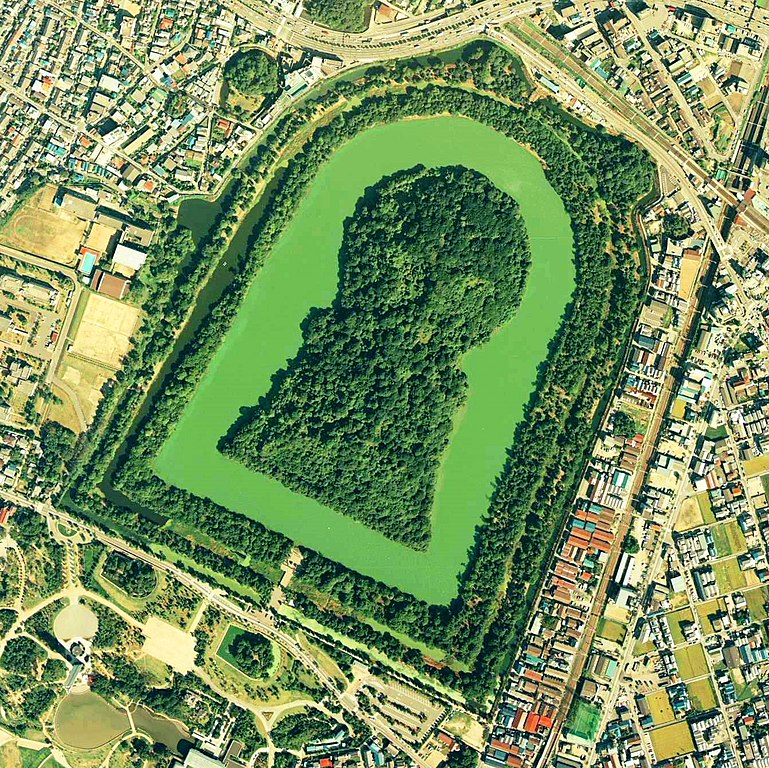
Daisen-kofun in Sakai, Osaka, Japan. This is one of the largest tombs in the world. Japanese government regards this as the tomb of Emperor Nintoku, the 16th emperor, but many historians don't think so. The keyhole-like tomb is 486m long, 305m wide at the bottom and 245m in diameter. English: Daisen-Kofun, the tomb of Emperor Nintoku, Osaka
Español: El Daisen-Kofun, tumba legendaria de Emperador Nintoku
Suomi: Kofun-kauden hautakumpu Osakassa, yksi maailman suurimmista. |
| Tarikh | |
| Sumber | http://w3land.mlit.go.jp/cgi-bin/WebGIS2/WC_AirPhoto.cgi?IT=p&DT=n&PFN=CKK-85-2&PCN=C2&IDX=8 |
| Pengarang | Ministry of Land, Infrastructure and Transport Government of Japan & moja resized |
| Kebenaran (Penggunaan semula fail ini) |
GFDL |
| Lokasi kamera | | Paparkan imej ini dan imej berdekatan yang lain di: OpenStreetMap |
|---|
- 仁徳天皇陵とされる古墳
- ソース
- 整理番号:CKK852-C2-8
- 撮影:1985年(昭和60年)

|
Pemegang hak cipta fail ini (the Ministry of Land, Infrastructure, Transport and Tourism of Japan) membenarkan sesiapa sahaja untuk menggunakannya untuk apa-apa jua tujuan, asalkan pemegang hak cipta diberi pengiktirafan yang sewajarnya. Pengedaran semula, kerja derivatif, kegunaan komersil dan semua kegunaan lain adalah dibenarkan. |
Pengiktirafan:
Copyright © National Land Image Information (Color Aerial Photographs), Ministry of Land, Infrastructure, Transport and Tourism
|
 |
This image is copyrighted by the Ministry of Land, Infrastructure, Transport and Tourism of Japan. For terms of use, see the stipulation to use of National Land Information (in Japanese) and message from MLIT (in Japanese and English). When you display this image on an article, include the following phrase in the description: "Made based on National Land Image Information (Color Aerial Photographs), Ministry of Land, Infrastructure, Transport and Tourism".
|
Sejarah fail
Klik pada tarikh/waktu untuk melihat rupa fail tersebut pada waktu itu.
| Tarikh/Waktu | Gambar kenit | Ukuran | Pengguna | Komen | |
|---|---|---|---|---|---|
| semasa | 09:19, 7 Jun 2020 | | 1,345 × 1,344 (2.38 MB) | 名古屋太郎 | 明るさ等変更 |
| 20:44, 17 Ogos 2005 |  | 800 × 800 (515 KB) | Moja~commonswiki | {{Information| |Description=Daisen-kofun in Sakai, Osaka, Japan. This is one of the largest tombs in the world. Japanese gorvernment regards this as the tomb of Emperor Nintoku, the 16th emperor, but many historians doubt don't think so. The keyhole-lik |
Penggunaan fail
Tiada laman yang menggunakan fail ini.
Penggunaan fail sejagat
Fail ini digunakan oleh wiki-wiki lain yang berikut:
- Penggunaan di en.wikipedia.org
- Penggunaan di fr.wikipedia.org
- Penggunaan di ja.wikipedia.org
- Penggunaan di www.wikidata.org
- Penggunaan di zh.wikipedia.org