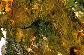
Gunung Cordón del Azufre
| Cordón del Azufre | |
|---|---|
 Imej komposit Landsat NASA | |
| Titik tertinggi | |
| Ketinggian | 5,481 m (17,982 ka) [1] |
| Koordinat | 25°20′S 68°30′W / 25.333°S 68.500°W [2] |
| Geografi | |
| Lokasi | Argentina, Chile[1] |
| Induk banjaran | Andes |
| Geologi | |
| Usia batuan | 0.3 ± 0.3 mya[3] |
| Jenis gunung | Gunung berapi kompleks[1] |
| Letusan terakhir | Tidak diketahui[1] |
Gunung Cordón del Azufre merupakan sebuah gunung di Argentina.
Rujukan[sunting | sunting sumber]
- ^ a b c d "Cordon del Azufre". Program Volkanisme Global, Institusi Smithsonian. http://www.volcano.si.edu/world/volcano.cfm?vnum=.
- ^ Anderssohn, Jan; Motagh, Mahdi; Walter, Thomas R.; Rosenau, Matthias; Kaufmann, Hermann; Oncken, Onno (October 2009). "Surface deformation time series and source modeling for a volcanic complex system based on satellite wide swath and image mode interferometry: The Lazufre system, central Andes". Remote Sensing of Environment. 113 (10): 2062–2075. Bibcode:2009RSEnv.113.2062A. doi:10.1016/j.rse.2009.05.004.
- ^ Froger, J.-L.; Remy, D.; Bonvalot, S.; Legrand, D. (March 2007). "Two scales of inflation at Lastarria-Cordon del Azufre volcanic complex, central Andes, revealed from ASAR-ENVISAT interferometric data". Earth and Planetary Science Letters. 255 (1–2): 148–163. Bibcode:2007E&PSL.255..148F. doi:10.1016/j.epsl.2006.12.012.
