
Fail:1891 Scotland Languages.jpg
Fail asli (633 × 858 piksel, saiz fail: 234 KB, jenis MIME: image/jpeg)
Ringkasan
| Keterangan |
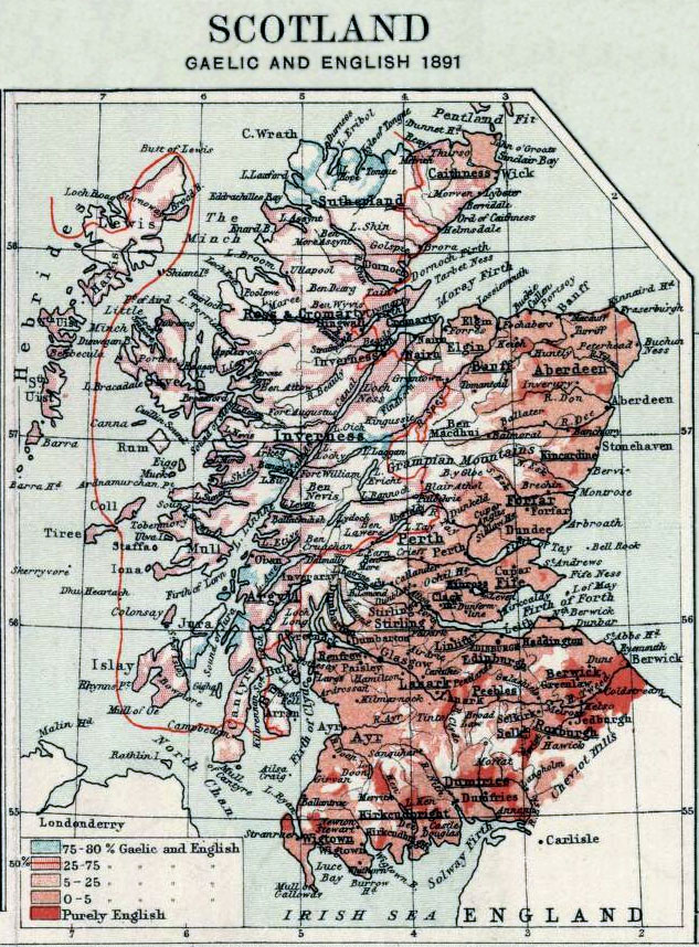
English: Map showing the use of Gaelic and English in Scotland in 1891. In effect, the map shows which areas were bilingual. The shaded areas show what percentage of the population in that area spoke both Gaelic and English.
Note the red line encircling much of the northwest mainland section of Scotland, inside which 50% of the population speaks Gaelic and English. To the south of that area, a smaller percentage of the population spoke Gaelic; to the west of that area, a smaller percentage of the population spoke English. In 1891, Gaelic was spoken by some part of the population across much of Scotland, and especially the northwest. |
| Tarikh | |
| Sumber | Small inset from Plate IX of J.G. Bartholomew's The Royal Scottish Geographical Society's Atlas of Scotland, Edinburgh: Edinburgh Geographical Institute, 1895 (excerpted and edited). Data based on the Census Report of 1891. |
| Pengarang | John Bartholomew and Son Ltd. |
Perlesenan
|
Karya ini berada dalam domain awam di negara-negara dengan tempoh hak cipta hayat pencipta ditambah 70 tahun atau kurang.
| |
| Fail ini telah dikenal pasti sebagai bebas daripada sekatan-sekatan yang dikenali mengikut undang-undang hak cipta, termasuk semua hak berkaitan dan berjiran. | |
Log muat naik asal
Transferred from en.wikipedia to Commons by Sreejithk2000 using CommonsHelper.
- 2006-02-16 16:13 Flux.books 633×858× (239907 bytes) Small inset from Plate 9 of J.G. Bartholomew's 'Survey Atlas of Scotland', 1895, excerpted and edited
Sejarah fail
Klik pada tarikh/waktu untuk melihat rupa fail tersebut pada waktu itu.
| Tarikh/Waktu | Gambar kenit | Ukuran | Pengguna | Komen | |
|---|---|---|---|---|---|
| semasa | 13:42, 28 Jun 2011 | | 633 × 858 (234 KB) | File Upload Bot (Magnus Manske) | {{BotMoveToCommons|en.wikipedia|year={{subst:CURRENTYEAR}}|month={{subst:CURRENTMONTHNAME}}|day={{subst:CURRENTDAY}}}} {{Information |Description={{en|Map showing the use of Gaelic and English in Scotland in 1891. In effect, the map shows which areas wer |
Penggunaan fail
Laman berikut menggunakan fail ini:
Penggunaan fail sejagat
Fail ini digunakan oleh wiki-wiki lain yang berikut:
- Penggunaan di en.wikipedia.org
- Penggunaan di en.wikiquote.org
- Penggunaan di hi.wikipedia.org
- Penggunaan di id.wikipedia.org
- Penggunaan di ur.wikipedia.org