
Fail:1906 Boatwright intensity.jpg

Saiz pralihat ini: 415 × 599 piksel. Leraian-leraian lain: 166 × 240 piksel | 612 × 884 piksel.
Fail asli (612 × 884 piksel, saiz fail: 539 KB, jenis MIME: image/jpeg)
Ringkasan
Public Domain
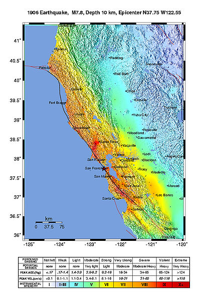
Intensity map for the 1906 San Francisco Earthquake deduced from the Lawson report
from U.S. Geological Survey Open-File Report 2005-1135
Modified Mercalli Intensity Maps for the 1906 San Francisco Earthquake Plotted in ShakeMap Format
By John Boatwright and Howard Bundock
Perlesenan
This image is in the public domain in the United States because it only contains materials that originally came from the United States Geological Survey, an agency of the United States Department of the Interior. For more information, see the official USGS copyright policy.
|
Sejarah fail
Klik pada tarikh/waktu untuk melihat rupa fail tersebut pada waktu itu.
| Tarikh/Waktu | Gambar kenit | Ukuran | Pengguna | Komen | |
|---|---|---|---|---|---|
| semasa | 21:45, 30 Mei 2006 | | 612 × 884 (539 KB) | Andre315 | Public Domain<br/> Intensity map for the 1906 San Francisco Earthquake deduced from the Lawson report<br/> from U.S. Geological Survey Open-File Report 2005-1135<br/> Modified Mercalli Intensity Maps for the 1906 San Francisco Earthquake Plotted in ShakeM |
Penggunaan fail
Laman berikut menggunakan fail ini:
Penggunaan fail sejagat
Fail ini digunakan oleh wiki-wiki lain yang berikut:
- Penggunaan di cs.wikipedia.org
- Penggunaan di de.wikipedia.org
- Penggunaan di en.wikipedia.org
- Penggunaan di fr.wikipedia.org
- Penggunaan di gl.wikipedia.org
- Penggunaan di hu.wikipedia.org
- Penggunaan di ka.wikipedia.org
- Penggunaan di ko.wikipedia.org
- Penggunaan di nl.wikipedia.org
- Penggunaan di tr.wikipedia.org