Fail:2013 Boston Marathon bombings map.png

Kandungan laman tidak disokong dalam bahasa lain.
Daripada Wikipedia, ensiklopedia bebas.

Fail asli(887 × 819 piksel, saiz fail: 680 KB, jenis MIME: image/png)

Fail ini dari Wikimedia Commons dan mungkin digunakan oleh projek lain. Penerangan pada laman penerangan failnya di sana ditunjukkan di bawah.

This city map image could be re-created using vector graphics as an SVG file. This has several advantages; see Commons:Media for cleanup for more information. If an SVG form of this image is available, please upload it and afterwards replace this template with {{vector version available|new image name}}.


It is recommended to name the SVG file “2013 Boston Marathon bombings map.svg”—then the template Vector version available (or Vva) does not need the new image name parameter.

Ringkasan

Keterangan
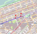
English: 2013 Boston Marathon bombings map.

The first bomb exploded at 671-673 Boylston Street, Boston, MA (42.349886, -71.078864): "MacDonald said one explosion had happened in front of the Marathon Sports store at 671-673 Boylston and the windows were blown out at a LensCrafters store, where 'the sidewalk is loaded with blood.'" 'Explosions rock Boston Marathon finish line; dozens injured', The Boston Globe. April 15, 2013 See also[1]

The marathon route is shown in dark blue, the finish line in yellow, and the area for runners only is in lighter blue. The family meeting area is in lighter yellow. See Boston Marathon Course Maps.
This map of Boston was created from OpenStreetMap project data, collected by the community. This map may be incomplete, and may contain errors. Don't rely solely on it for navigation.
Tarikh
Sumber You may find a page on the OpenStreetMap wiki page for Boston
Pencipta
OpenStreetMap contributors
Kebenaran
(Penggunaan semula fail ini)

OpenStreetMap data is available under the Open Database License (details). Map tiles are licensed under the Creative Commons Attribution-ShareAlike 2.0 license (CC-BY-SA 2.0).

This work contains information from OpenStreetMap, which is made available under the Open Database License (ODbL).

The ODbL does not require any particular license for maps produced from ODbL data. Prior to 1 August 2020, map tiles produced by the OpenStreetMap Foundation were licensed under the CC-BY-SA-2.0 license. Maps produced by other people may be subject to other licences.

w:ms:Creative Commons
pengiktirafan perkongsian serupa
Anda bebas:
  • untuk berkongsi – untuk menyalin, mengedar dan memindah hasil kerja
  • untuk mencampur semula – untuk menyesuaikan karya
Di bawah syarat berikut:
  • pengiktirafan – Anda mesti memberi penghargaan yang berpatutan, bekalkan pautan ke lesen, dan tunjukkan jika perubahan telah dibuat. Anda boleh lakukannya dalam sebarang cara yang munasabah, tetapi bukan dalam sebarang cara yang mencadangkan pemberi lesen mengendors anda atau penggunaan anda.
  • perkongsian serupa – Jika anda mengubah, adun semula, atau menokok tambah bahan, anda mesti menyebarkan sumbangan anda di bawah lesen yang sama atau serasi dengan yang asal.
Georeferencing Georeference the map in Wikimaps Warper If inappropriate please set warp_status = skip to hide.


Perlesenan

This work contains information from OpenStreetMap, which is made available under the Open Database License (ODbL).

The ODbL does not require any particular license for maps produced from ODbL data. Prior to 1 August 2020, map tiles produced by the OpenStreetMap Foundation were licensed under the CC-BY-SA-2.0 license. Maps produced by other people may be subject to other licences.

w:ms:Creative Commons
pengiktirafan perkongsian serupa
Anda bebas:
  • untuk berkongsi – untuk menyalin, mengedar dan memindah hasil kerja
  • untuk mencampur semula – untuk menyesuaikan karya
Di bawah syarat berikut:
  • pengiktirafan – Anda mesti memberi penghargaan yang berpatutan, bekalkan pautan ke lesen, dan tunjukkan jika perubahan telah dibuat. Anda boleh lakukannya dalam sebarang cara yang munasabah, tetapi bukan dalam sebarang cara yang mencadangkan pemberi lesen mengendors anda atau penggunaan anda.
  • perkongsian serupa – Jika anda mengubah, adun semula, atau menokok tambah bahan, anda mesti menyebarkan sumbangan anda di bawah lesen yang sama atau serasi dengan yang asal.

Captions

Add a one-line explanation of what this file represents

MIME type Inggeris

image/png

f09e12d0a04535bb38f8da7b06ba68c31f0dc97a

696,674 bait

819 piksel

887 piksel

Sejarah fail

Klik pada tarikh/waktu untuk melihat rupa fail tersebut pada waktu itu.

Tarikh/WaktuGambar kenitUkuranPenggunaKomen
semasa18:06, 17 April 2013Gambar kenit bagi versi pada 18:06, 17 April 2013887 × 819 (680 KB)Aptevaroute correction
03:13, 17 April 2013Gambar kenit bagi versi pada 03:13, 17 April 2013887 × 819 (705 KB)Ke4rohAdd route information - marathon course dark blue, finish line yellow, runner only area light blue, family meeting area yellow
00:10, 16 April 2013Gambar kenit bagi versi pada 00:10, 16 April 2013887 × 819 (712 KB)Odderthe first blast was too far left; pictures suggest the blasts took place on the sidewalk, and not in the middle of the street
23:50, 15 April 2013Gambar kenit bagi versi pada 23:50, 15 April 2013887 × 819 (711 KB)Oddernumbers, circle => 9-pointed star, reduced size of the blast indicators per talk page comment
23:45, 15 April 2013Gambar kenit bagi versi pada 23:45, 15 April 2013887 × 819 (556 KB)Anna Frodesiakadjust location of second blast
23:05, 15 April 2013Gambar kenit bagi versi pada 23:05, 15 April 2013887 × 819 (555 KB)Anna Frodesiakversion showing site of second blast
22:51, 15 April 2013Gambar kenit bagi versi pada 22:51, 15 April 2013887 × 819 (556 KB)Anna Frodesiakversion showing first blast site
22:46, 15 April 2013Gambar kenit bagi versi pada 22:46, 15 April 2013887 × 819 (515 KB)Anna FrodesiakUser created page with UploadWizard

Penggunaan fail sejagat

Fail ini digunakan oleh wiki-wiki lain yang berikut:

Metadata