
Fail:Geographical and Magnetic Poles.png

Saiz pralihat ini: 668 × 599 piksel. Leraian-leraian lain: 268 × 240 piksel | 535 × 480 piksel | 856 × 768 piksel | 1,028 × 922 piksel.
Fail asli (1,028 × 922 piksel, saiz fail: 174 KB, jenis MIME: image/png)
תרשים סכמטי של כדור הארץ
- A = ציר הסיבוב של כדור הארץ (מסומן בקו ירוק)
- A1 A2 = הקטבים הגאוגרפיים - הנקודות שבהן "חותך" ציר הסיבוב את פני כדור הארץ.
- הגלעין החיצוני (נוזלי) (מסומן בצבע אפור) - שכבה בכדור הארץ שבה נוצר השדה המגנטי, על פי w:he:תאוריית הדינמו.
- B = ציר הדו-קוטביות (מסומן בקו כחול) - הציר המגנטי הדו-קוטבי, המדמה מעין מוט מגנטי, שחלקו הצפוני הוא מגנט שמבחינה פיזיקלית נחשב ל"דרומי" (מסומן ב-S = South = דרום), ואילו חלקו הדרומי נחשב ל"צפוני" (N = North = צפון) מבחינה פיזיקלית. כיום, הזווית בין ציר זה לבין ציר הסיבוב של כדור הארץ היא 11.3°.
- B1 B2 = הקטבים הגאומגנטיים - הנקודות שבהן "חותך" ציר הדו-קוטביות את פני כדור הארץ.
- קווי השדה המגנטי (קווים שחורים דקים) - מתארים את כיוון השדה המגנטי מחוץ לגלעין.
- C1 C2 = הקטבים המגנטיים - הנקודות שבהן קווי השדה המגנטי (מסומנים בקווים שחורים) מאונכים לפני כדור הארץ (זווית של 90° בדיוק בגובה פני הקרקע). הקטבים המגנטיים אינם חופפים לקטבים הגאומגנטיים.
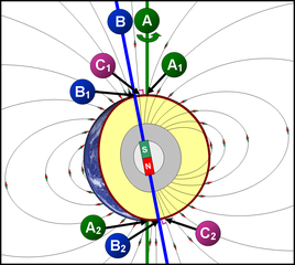
Schematic diagram of the Earth
- A = Earth's axis of rotation (marked with a green line)
- A1 A2 = the geographical poles - the points at which the axis of rotation "cuts" the axis of rotation of the earth.
- The outer core (liquid) (marked in gray) - a layer on Earth where the magnetic field is formed, according to the dynamo theory.
- B = Bipolar Axis (marked with a blue line) - The bipolar magnetic axis, which simulates a kind of magnetic rod, the northern part of which is a magnet that is physically considered "southern" (marked with S = South = South), while its southern part Is considered "North" (N = North = North) physically. Today, the angle between this axis and the axis of rotation of the Earth is 11.3 °.
- B1 B2 = the geomagnetic poles - the points at which the bipolar axis "cuts" the earth's surface.
- Magnetic field lines (thin black lines) - describe the direction of the magnetic field outside the nucleus.
- C1 C2 = The magnetic poles - the points at which the magnetic field lines (marked with black lines) are perpendicular to the Earth (an angle of 90 ° exactly at ground level). The magnetic poles do not overlap with the geomagnetic poles.
Ringkasan
| Keterangan | A=Geographic poles, B=Geomagnetic poles, C=Magnetic poles |
| Tarikh | |
| Sumber | Karya sendiri |
| Pengarang | DMY |
Perlesenan
Dengan ini, saya selaku pemegang hak cipta karya ini, menerbitkannya di bawah lesen-lesen yang berikut:

|
Kebenaran diberikan untuk menyalin, mengedar dan/atau mengubah dokumen ini di bawah syarat-syarat Lesen Pendokumenan Bebas GNU, versi 1.2 atau mana-mana versi selepas ini, yang diterbitkan oleh Yayasan Perisian Bebas; tanpa Seksyen yang Tak Berubah, tanpa Teks Kulit Depan dan tanpa Teks Kulit Belakang. Salinan lesen ini boleh didapati dalam seksyen yang bertajuk Lesen Pendokumenan Bebas GNU". |
Fail ini dilesenkan di bawah lesen Pengiktirafan 3.0 Tidak Diport Creative Commons.
- Anda bebas:
- untuk berkongsi – untuk menyalin, mengedar dan memindah hasil kerja
- untuk mencampur semula – untuk menyesuaikan karya
- Di bawah syarat berikut:
- pengiktirafan – Anda mesti memberi penghargaan yang berpatutan, bekalkan pautan ke lesen, dan tunjukkan jika perubahan telah dibuat. Anda boleh lakukannya dalam sebarang cara yang munasabah, tetapi bukan dalam sebarang cara yang mencadangkan pemberi lesen mengendors anda atau penggunaan anda.
Anda boleh memilih mana-mana lesen yang anda mahukan.
Sejarah fail
Klik pada tarikh/waktu untuk melihat rupa fail tersebut pada waktu itu.
| Tarikh/Waktu | Gambar kenit | Ukuran | Pengguna | Komen | |
|---|---|---|---|---|---|
| semasa | 09:11, 13 November 2007 | | 1,028 × 922 (174 KB) | DMY | |
| 20:43, 11 November 2007 |  | 1,028 × 922 (211 KB) | DMY | ||
| 20:23, 11 November 2007 |  | 1,018 × 912 (210 KB) | DMY | == Summary == {{Information |Description=A=Geographic poles, B=Geomagnetic poles, C=Magnetic poles |Source=self-made |Date=Nov 3, 2007 |Author= DMY |Permission= |other_versions= }} == Licensing == {{self|GFDL|cc-by-3.0}} |
Penggunaan fail
Laman berikut menggunakan fail ini:
Penggunaan fail sejagat
Fail ini digunakan oleh wiki-wiki lain yang berikut:
- Penggunaan di ar.wikipedia.org
- Penggunaan di ast.wikipedia.org
- Penggunaan di bn.wikipedia.org
- Penggunaan di ca.wikipedia.org
- Penggunaan di cs.wikipedia.org
- Penggunaan di cy.wikipedia.org
- Penggunaan di el.wikipedia.org
- Penggunaan di en.wikipedia.org
- Penggunaan di en.wikibooks.org
- Penggunaan di eu.wikipedia.org
- Penggunaan di fr.wikipedia.org
- Penggunaan di he.wikipedia.org
- Penggunaan di ht.wikipedia.org
- Penggunaan di it.wikipedia.org
- Penggunaan di ja.wikipedia.org
- Penggunaan di ko.wikipedia.org
- Penggunaan di mk.wikipedia.org
- Penggunaan di ne.wikipedia.org
- Penggunaan di nl.wikipedia.org
- Penggunaan di nl.wikibooks.org
- Penggunaan di pl.wikipedia.org
- Penggunaan di pt.wikipedia.org
- Penggunaan di simple.wikipedia.org
- Penggunaan di sr.wikipedia.org
- Penggunaan di uz.wikipedia.org
- Penggunaan di vi.wikipedia.org
- Penggunaan di www.wikidata.org