
Fail:Nauru map.jpg

Saiz pralihat ini: 484 × 600 piksel. Leraian-leraian lain: 194 × 240 piksel | 387 × 480 piksel | 994 × 1,232 piksel.
Fail asli (994 × 1,232 piksel, saiz fail: 128 KB, jenis MIME: image/jpeg)

|
This locator map image could be re-created using vector graphics as an SVG file. This has several advantages; see Commons:Media for cleanup for more information. If an SVG form of this image is available, please upload it and afterwards replace this template with
{{vector version available|new image name}}.
It is recommended to name the SVG file “Nauru map.svg”—then the template Vector version available (or Vva) does not need the new image name parameter. |


Ringkasan
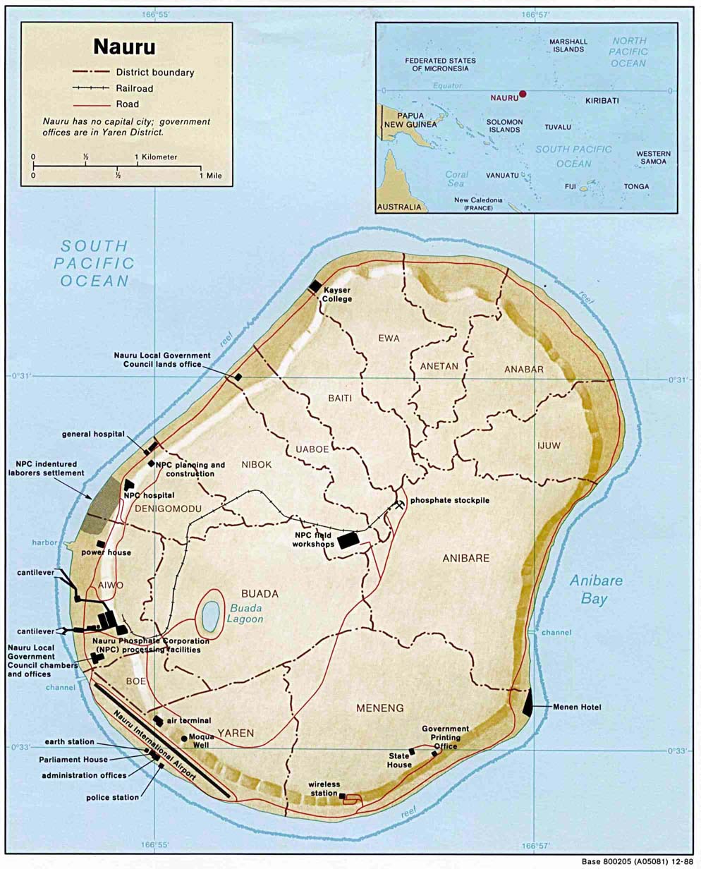
| Keterangan | Small-label map of the island of Nauru (click image to enlarge for reading labels), northeast of Australia, north of the Solomon Islands and northwest of Fiji. The island is surrounded by a coral reef ring. The map shows some detailed contour areas near the shoreline. |
| Tarikh | |
| Sumber | Nauru (Shaded Relief) 1988 from Library Map Collection: Maps of Australia and the Pacific |
| Pengarang | U.S. Central Intelligence Agency |
| Kebenaran (Penggunaan semula fail ini) |
Public domain |
| Versi lain |
Same map with larger labels: Image:Nauru_map_bold.jpg (has larger labels of nearby areas, the oceans, and district names). |
Perlesenan
| This image is a work of a Central Intelligence Agency employee, taken or made as part of that person's official duties. As a Work of the United States Government, this image or media is in the public domain in the United States.
|

|
Sejarah fail
Klik pada tarikh/waktu untuk melihat rupa fail tersebut pada waktu itu.
| Tarikh/Waktu | Gambar kenit | Ukuran | Pengguna | Komen | |
|---|---|---|---|---|---|
| semasa | 23:48, 26 Mac 2005 | | 994 × 1,232 (128 KB) | Jon Harald Søby | From the English Wikipedia. {{PD-USGov}} |
Penggunaan fail
Laman berikut menggunakan fail ini:
Penggunaan fail sejagat
Fail ini digunakan oleh wiki-wiki lain yang berikut:
- Penggunaan di azb.wikipedia.org
- Penggunaan di bg.wikipedia.org
- Penggunaan di en.wikipedia.org
- Penggunaan di he.wikipedia.org
- נאורו
- תבנית:הידעת? 11 באפריל - סדרה 2
- ויקיפדיה:הידעת?/2014/יולי
- תבנית:הידעת? 11 ביולי 2014
- ויקיפדיה:הידעת?/2016/אפריל
- תבנית:הידעת? 14 באפריל 2016
- ויקיפדיה:הידעת?/2018/אפריל
- תבנית:הידעת? 10 באפריל 2018
- ויקיפדיה:הידעת?/2020/אפריל
- תבנית:הידעת? 11 באפריל 2020
- פורטל:מדע המדינה/הידעת?/קטעי הידעת?
- פורטל:מדע המדינה/הידעת?/16
- פורטל:מדעי החברה/הידעת?/קטעי הידעת?
- פורטל:מדעי החברה/הידעת?/79
- ויקיפדיה:הידעת?/2023/אפריל
- תבנית:הידעת? 11 באפריל 2023
- Penggunaan di id.wikipedia.org
- Penggunaan di incubator.wikimedia.org
- Penggunaan di ja.wikipedia.org
- Penggunaan di jv.wikipedia.org
- Penggunaan di ka.wikipedia.org
- Penggunaan di sv.wikipedia.org
- Penggunaan di uk.wikipedia.org