
Fail:Ottoman Provinces Of Present day Libya.png
Tiada leraian lebih besar.
Ottoman_Provinces_Of_Present_day_Libya.png (282 × 314 piksel, saiz fail: 22 KB, jenis MIME: image/png)

|
This locator map image could be re-created using vector graphics as an SVG file. This has several advantages; see Commons:Media for cleanup for more information. If an SVG form of this image is available, please upload it and afterwards replace this template with
{{vector version available|new image name}}.
It is recommended to name the SVG file “Ottoman Provinces Of Present day Libya.svg”—then the template Vector version available (or Vva) does not need the new image name parameter. |
Ringkasan
| Keterangan |
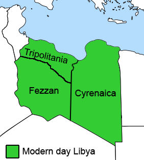
English: The Ottoman Turks conquered the country in the mid-16th century, and the three States or "Wilayat" of Tripolitania, Cyrenaica and Fezzan (which make up Libya) remained part of their empire with the exception of the virtual autonomy of the Karamanlis. The Karamanlis ruled from 1711 until 1835 mainly in Tripolitania, but had influence in Cyrenaica and Fezzan as well by the mid 18th century. |
||
| Tarikh | |||
| Sumber | self-made but based on this image on this image and this image | ||
| Pengarang | Esemono; improved by Kirk (talk) | ||
| Kebenaran (Penggunaan semula fail ini) |
|
||
| Versi lain |
Derivative works of this file:
   |
Sejarah fail
Klik pada tarikh/waktu untuk melihat rupa fail tersebut pada waktu itu.
| Tarikh/Waktu | Gambar kenit | Ukuran | Pengguna | Komen | |
|---|---|---|---|---|---|
| semasa | 12:53, 24 Ogos 2011 | | 282 × 314 (22 KB) | Kirk979 | See discussion |
| 20:46, 11 April 2011 |  | 300 × 350 (35 KB) | ANGELUS | border | |
| 20:35, 11 April 2011 |  | 300 × 350 (39 KB) | ANGELUS | improved | |
| 17:35, 12 Oktober 2009 |  | 282 × 314 (22 KB) | Kirk979 | corrections | |
| 11:00, 1 Mac 2009 |  | 282 × 314 (29 KB) | Kirk979 | corrections | |
| 13:43, 17 April 2008 |  | 282 × 314 (25 KB) | Esemono | Category:Maps of Libya Category:Map images that should use vector graphics |
Penggunaan fail
Laman berikut menggunakan fail ini:
Penggunaan fail sejagat
Fail ini digunakan oleh wiki-wiki lain yang berikut:
- Penggunaan di ar.wikipedia.org
- Penggunaan di azb.wikipedia.org
- Penggunaan di az.wikipedia.org
- Penggunaan di be.wikipedia.org
- Penggunaan di bg.wikipedia.org
- Penggunaan di bs.wikipedia.org
- Penggunaan di ca.wikipedia.org
- Penggunaan di cs.wikipedia.org
- Penggunaan di da.wikipedia.org
- Penggunaan di el.wikipedia.org
- Penggunaan di en.wikipedia.org
- Cyrenaica
- Districts of Libya
- Fezzan
- Tripolitania
- Governorates of Libya
- Subdivisions of Libya
- Provinces of Libya
- Postage stamps and postal history of Tripolitania
- Kingdom of Libya
- Postage stamps and postal history of Cyrenaica
- Postage stamps and postal history of Libya
- Postage stamps and postal history of Fezzan and Ghadames
- Template:Regions of Libya
- Category:Regions of Libya
- Revenue stamps of Libya
- Tripolitania (province of Libya)
- Cyrenaica province
- Fezzan province
Lihat banyak lagi penggunaan sejagat bagi fail ini.