
Fail:PIA10214.jpg

Fail asli (12,756 × 3,487 piksel, saiz fail: 5.58 MB, jenis MIME: image/jpeg)
Ringkasan
| Keterangan |
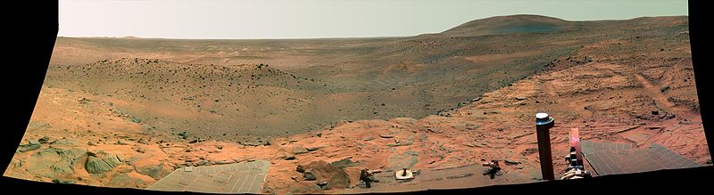
Spirit's West Valley Panorama (Color not rectificated for media) NASA'S Mars Exploration Rover Spirit captured this westward view from atop a low plateau where Sprit spent the closing months of 2007. After several months near the base of the plateau called "Home Plate" in the inner basin of the Columbia Hills range inside Gusev Crater, Spirit climbed onto the eastern edge of the plateau during the rover's 1,306th Martian day, or sol, (Sept. 5, 2007). It examined rocks and soils at several locations on the southern half of Home Plate during September and October. It was perched near the western edge of Home Plate when it used its panoramic camera (Pancam) to take the images used in this view on sols 1,366 through 1,369 (Nov. 6 through Nov. 9, 2007). With its daily solar-energy supply shrinking as Martian summer turned to fall, Spirit then drove to the northern edge of Home Plate for a favorable winter haven. The rover reached that northward-tilting site in December, in time for the fourth Earth-year anniversary of its landing on Mars. Spirit reached Mars on Jan. 4, 2004, Universal Time (Jan. 3, 2004, Pacific Standard Time). It landed at a site at about the center of the horizon in this image. This panorama covers a scene spanning left to right from southwest to northeast. The western edge of Home Plate is in the foreground, generally lighter in tone than the more distant parts of the scene. A rock-dotted hill in the middle distance across the left third of the image is "Tsiolkovski Ridge," about 30 meters or 100 feet from the edge of Home Plate and about that same distance across. A bump on the horizon above the left edge of Tsiolkovski Ridge is "Grissom Hill," about 8 kilometers or 5 miles away. At right, the highest point of the horizon is "Husband Hill," to the north and about 800 meters or half a mile away. This view combines separate images taken through Pancam filters centered on wavelengths of 753 nanometers, 535 nanometers and 432 nanometers. It is presented in a false-color stretch to bring out subtle color differences in the scene. |
| Tarikh | November 6-9, 2007 |
| Sumber | http://photojournal.jpl.nasa.gov/catalog/PIA10214 |
| Pengarang | NASA |
This image or video was catalogued by Jet Propulsion Laboratory of the United States National Aeronautics and Space Administration (NASA) under Photo ID: PIA10214. This tag does not indicate the copyright status of the attached work. A normal copyright tag is still required. See Commons:Licensing. Other languages:
|
Perlesenan
| This file is in the public domain in the United States because it was solely created by NASA. NASA copyright policy states that "NASA material is not protected by copyright unless noted". (See Template:PD-USGov, NASA copyright policy page or JPL Image Use Policy.) | ||
 |
Warnings:
|
| Annotations | This image is annotated: View the annotations at Commons |
Sejarah fail
Klik pada tarikh/waktu untuk melihat rupa fail tersebut pada waktu itu.
| Tarikh/Waktu | Gambar kenit | Ukuran | Pengguna | Komen | |
|---|---|---|---|---|---|
| semasa | 04:31, 16 Mac 2008 | 12,756 × 3,487 (5.58 MB) | Sistemx~commonswiki | {{Information |Description= a photo of mars |Source=of internate |Date= 15 of march/2008 |Author= |Permission=no |other_versions= }} |
Penggunaan fail
Laman berikut menggunakan fail ini:
Penggunaan fail sejagat
Fail ini digunakan oleh wiki-wiki lain yang berikut:
- Penggunaan di en.wikipedia.org
- Penggunaan di es.wikipedia.org
- Penggunaan di zh.wikipedia.org