
Fail:PanAmericanHwy.png

Saiz pralihat ini: 434 × 599 piksel. Leraian-leraian lain: 174 × 240 piksel | 348 × 480 piksel | 556 × 768 piksel | 742 × 1,024 piksel | 1,600 × 2,208 piksel.
Fail asli (1,600 × 2,208 piksel, saiz fail: 2.08 MB, jenis MIME: image/png)

|
This road map image could be re-created using vector graphics as an SVG file. This has several advantages; see Commons:Media for cleanup for more information. If an SVG form of this image is available, please upload it and afterwards replace this template with
{{vector version available|new image name}}.
It is recommended to name the SVG file “PanAmericanHwy.svg”—then the template Vector version available (or Vva) does not need the new image name parameter. |
Ringkasan
| Keterangan |
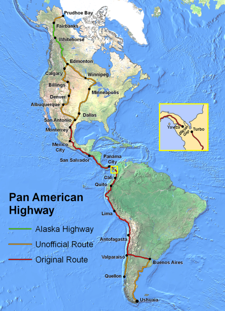
English: Route of the Pan-American Highway. Includes original route and unofficial extensions but doesn't reflect official designation of U.S. interstate highway system. Hotine Oblique Mercator Two Point Natural Origin Projection. |
| Sumber | Karya sendiri |
| Pengarang | Created by en:User:Seaweege and released to PD |
Perlesenan

|
The copyright holder of this work allows anyone to use it for any purpose including unrestricted redistribution, commercial use, and modification.
Usage notes:
|
Sejarah fail
Klik pada tarikh/waktu untuk melihat rupa fail tersebut pada waktu itu.
| Tarikh/Waktu | Gambar kenit | Ukuran | Pengguna | Komen | |
|---|---|---|---|---|---|
| semasa | 02:32, 18 Januari 2022 | | 1,600 × 2,208 (2.08 MB) | Natewich | Route of the Pan American Highway. Includes original route and unofficial extensions. Hotine Oblique Mercator Two Point Natural Origin Projection. Taken from en:Image:PanAmericanHwy.png. |
| 01:33, 27 November 2007 |  | 1,325 × 1,828 (3.72 MB) | Jabul | Route of the Pan American Highway. Includes original route and unofficial extensions. Hotine Oblique Mercator Two Point Natural Origin Projection. Taken from en:Image:PanAmericanHwy.png. | |
| 01:18, 27 November 2007 |  | 1,325 × 1,828 (3.72 MB) | Jabul | ||
| 02:36, 17 Jun 2007 |  | 1,325 × 1,828 (3.6 MB) | SchuminWeb | {{Information |Description=Route of the Pan American Highway. Includes original route and unofficial extensions. Hotine Oblique Mercator Two Point Natural Origin Projection |Source=Originally from [http://en.wikipedia.org en.wikipedia]; description page | |
| 15:26, 29 Disember 2006 |  | 1,700 × 2,200 (3.62 MB) | Chigliak | Original Description: Route of the Pan American Highway. Includes original route and unofficial extensions. Hotine Oblique Mercator Two Point Natural Origin Projection. Taken from en:Image:PanAmericanHwy.png. Created by en:User:Seaweege and rea |
Penggunaan fail
4 buah laman berikut menggunakan fail ini:
Penggunaan fail sejagat
Fail ini digunakan oleh wiki-wiki lain yang berikut:
- Penggunaan di ar.wikipedia.org
- Penggunaan di be-tarask.wikipedia.org
- Penggunaan di be.wikipedia.org
- Penggunaan di bg.wikipedia.org
- Penggunaan di bn.wikipedia.org
- Penggunaan di cs.wikipedia.org
- Penggunaan di de.wikipedia.org
- Penggunaan di de.wikivoyage.org
- Penggunaan di el.wikipedia.org
- Penggunaan di en.wikipedia.org
- Penggunaan di en.wikivoyage.org
- Penggunaan di eo.wikipedia.org
- Penggunaan di et.wikipedia.org
- Penggunaan di eu.wikipedia.org
- Penggunaan di fa.wikipedia.org
- Penggunaan di fi.wikipedia.org
- Penggunaan di fr.wikipedia.org
- Penggunaan di he.wikipedia.org
- Penggunaan di hi.wikibooks.org
- Penggunaan di id.wikipedia.org
- Penggunaan di it.wikipedia.org
- Penggunaan di ja.wikipedia.org
- Penggunaan di ka.wikipedia.org
- Penggunaan di km.wikipedia.org
- Penggunaan di ko.wikipedia.org
- Penggunaan di lt.wikipedia.org
- Penggunaan di ml.wikipedia.org
- Penggunaan di mr.wikipedia.org
- Penggunaan di nl.wikipedia.org
- Penggunaan di no.wikipedia.org
- Penggunaan di pl.wikipedia.org
Lihat banyak lagi penggunaan sejagat bagi fail ini.