
Fail:WW2-Holocaust-Poland.PNG
Fail asli (2,007 × 2,161 piksel, saiz fail: 1.34 MB, jenis MIME: image/png)

|
This map image could be re-created using vector graphics as an SVG file. This has several advantages; see Commons:Media for cleanup for more information. If an SVG form of this image is available, please upload it and afterwards replace this template with
{{vector version available|new image name}}.
It is recommended to name the SVG file “WW2-Holocaust-Poland.svg”—then the template Vector version available (or Vva) does not need the new image name parameter. |
Ringkasan
| Keterangan |
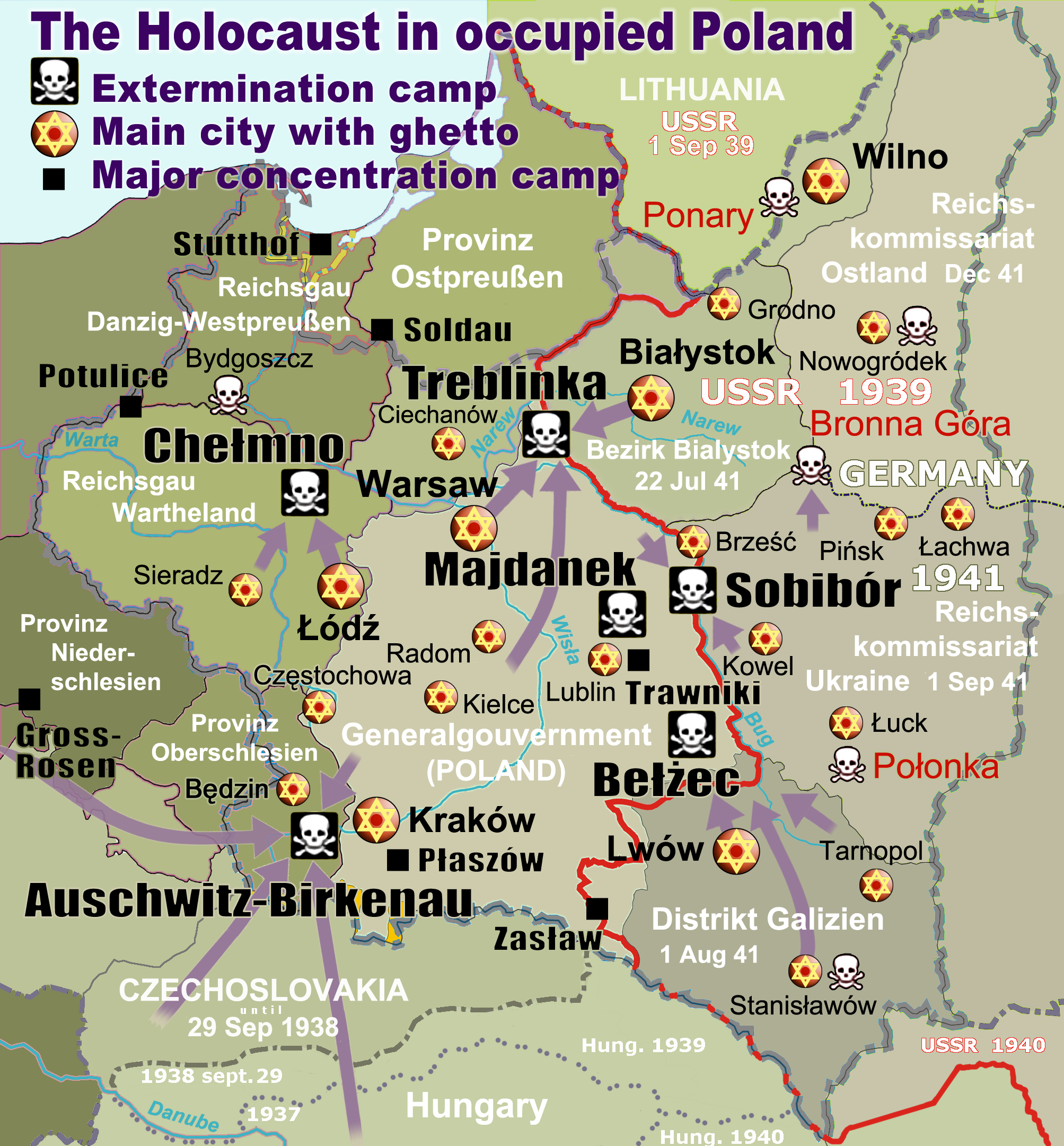
English: Map of the Holocaust in occupied Poland during World War II. The outline shows the borders of the Second Polish Republic at the time of the Nazi-German-and-Soviet invasion of Poland in 1939 with demarcation line between the two invading armies marked in red. Internal boundaries show the administrative divisions of occupied territories imposed by Nazi Germany when the Final Solution was set in motion during and after Operation Barbarossa of 1941. This map shows all Nazi German extermination camps (or death camps), as well as prominent concentration, labour and prison camps, major pre-WW2 Polish cities with the new Jewish ghettos set up by Nazi Germany, major deportation routes, and major massacre sites. Notes: 1. Extermination camps – marked with white skulls in black squares – are six dedicated facilities used for the mass gassings of prisoners, but all camps and ghettos took a toll of many, many lives. 2. Concentration camps – marked with black squares – feature only the most notorious forced-labor camps, prison camps & transit camps. 3. Sites of mass shootings into remote ravines – marked with white skulls – include Bronna Góra, Ponary and others. They were utilized during the 'Holocaust by bullets'. 4. Destruction ghettos – marked with Yellow stars in red circles – existed in most Polish cities. Only a selection is shown. 5. Major deportation routes travelled by the Holocaust trains are marked with RosyBrown arrows. 6. Most camps & ghettos which are not well known have been excluded for clarity. 7. District borders are at the height of Axis domination (1942). 8. Regions have German designations (e.g. "Ostland"), with the country name denoted in uppercase letters, e.g. LITHUANIA, CZECHOSLOVAKIA, or in parenthesis below the German occupational designation, e.g. (POLAND). |
| Tarikh | |
| Sumber |
Karya sendiri. Composite map derived from a variety of readily available sources which may or may not include:
|
| Pengarang |
|
| Kebenaran (Penggunaan semula fail ini) |
PD, see below. The map is completely unrestricted for any Wikipedia/Wikimedia project. |
| Versi lain |
[]
|


.png)


.png)


Perlesenan
For all derivative works of maps uploaded earlier see below.
| Saya selaku pemegang hak cipta karya ini melepaskan karya ini ke dalam domain awam di seluruh dunia. Di sesetengah negara, undang-undangnya mungkin tidak mengizinkan; jika begitu: Saya memberi sesiapa sahaja hak untuk menggunakan karya ini untuk apa jua tujuan, tanpa sebarang syarat, melainkan undang-undang menetapkan syarat-syarat sedemikian. |
- File uploaded previously
- Anda bebas:
- untuk berkongsi – untuk menyalin, mengedar dan memindah hasil kerja
- untuk mencampur semula – untuk menyesuaikan karya
- Di bawah syarat berikut:
- pengiktirafan – Anda mesti memberi penghargaan yang berpatutan, bekalkan pautan ke lesen, dan tunjukkan jika perubahan telah dibuat. Anda boleh lakukannya dalam sebarang cara yang munasabah, tetapi bukan dalam sebarang cara yang mencadangkan pemberi lesen mengendors anda atau penggunaan anda.
Derivative work: Piotr Konieczny aka Prokonsul Piotrus Talk Derivative works of this file:
Derivative work: User:Poeticbent (Talk) Derivative works of this file:
- Uploaded previously
| Ini adalah gambar sentuh, ini bermakna bahawa ia telah didigitalkan dari versi asal. Modifikasi: Smaller version: occupied Poland only (pre-WWII borders). Versi asal boleh dilihat di sini: WW2-Holocaust-Europe.png.
|
- Anda bebas:
- untuk berkongsi – untuk menyalin, mengedar dan memindah hasil kerja
- untuk mencampur semula – untuk menyesuaikan karya
- Di bawah syarat berikut:
- pengiktirafan – Anda mesti memberi penghargaan yang berpatutan, bekalkan pautan ke lesen, dan tunjukkan jika perubahan telah dibuat. Anda boleh lakukannya dalam sebarang cara yang munasabah, tetapi bukan dalam sebarang cara yang mencadangkan pemberi lesen mengendors anda atau penggunaan anda.
Log muat naik asal
For derivative works of the first uploaded file created by User:Dna-webmaster see the following:
- File:WW2-Holocaust-Europe.png licensed with Cc-by-3.0
Uploaded with derivativeFX
Sejarah fail
Klik pada tarikh/waktu untuk melihat rupa fail tersebut pada waktu itu.
| Tarikh/Waktu | Gambar kenit | Ukuran | Pengguna | Komen | |
|---|---|---|---|---|---|
| semasa | 15:46, 10 Mac 2020 | | 2,007 × 2,161 (1.34 MB) | Claude Zygiel | Cosmetics |
| 20:33, 28 Mac 2018 |  | 2,007 × 2,161 (1.48 MB) | Poeticbent | not an improvement: img looks muddy but I have original Photoshop layers, and can adjust them individually; comment on specifics in talk please | |
| 17:48, 27 Mac 2018 |  | 2,007 × 2,161 (1.49 MB) | Hohum | Too much information competing for attention in a very busy image. Toned down region name brightness, desaturated slightly. | |
| 05:38, 10 Julai 2017 |  | 2,007 × 2,161 (1.48 MB) | Poeticbent | vital updates following a discussion → prominent ghettos, legend | |
| 19:43, 25 Julai 2015 |  | 2,007 × 2,161 (1.46 MB) | Poeticbent | name of settlement: Górka Połonka, source Wolyn.ovh.org | |
| 18:27, 2 Disember 2014 |  | 2,007 × 2,161 (1.46 MB) | Poeticbent | added one missing marker | |
| 19:17, 7 Mei 2014 |  | 2,007 × 2,161 (1.45 MB) | Poeticbent | location of Bronna Góra | |
| 17:34, 4 April 2014 |  | 2,007 × 2,161 (1.44 MB) | Poeticbent | Lachwa Ghetto location | |
| 21:31, 27 Jun 2013 |  | 2,007 × 2,161 (1.42 MB) | Poeticbent | major expansion with similar color-scheme | |
| 03:09, 28 Jun 2011 |  | 364 × 339 (123 KB) | LMK3 | changed the color of the Soviet Curzon line to indicate the two different occupation zones before Operation Barbarossa, refined the location of Warsaw |
Penggunaan fail
Laman berikut menggunakan fail ini:
Penggunaan fail sejagat
Fail ini digunakan oleh wiki-wiki lain yang berikut:
- Penggunaan di ar.wikipedia.org
- Penggunaan di azb.wikipedia.org
- Penggunaan di az.wikipedia.org
- Penggunaan di bg.wikipedia.org
- Penggunaan di bn.wikipedia.org
- Penggunaan di br.wikipedia.org
- Penggunaan di ca.wikipedia.org
- Penggunaan di cs.wikipedia.org
- Penggunaan di cs.wikibooks.org
- Penggunaan di da.wikipedia.org
- Penggunaan di de.wikipedia.org
- Penggunaan di el.wikipedia.org
- Γκέτο της Τσενστοχόβα
- Γκέτο του Μπέντζιν
- Γκέτο του Μίζοτς
- Μπρόνα Γκούρα
- Γκέτο της Κρακοβίας
- Γκέτο του Μπζέσκο
- Στρατόπεδο συγκέντρωσης Τραβνίκι
- Στρατόπεδο συγκέντρωσης Ποτουλίτσε
- Γκέτο του Σοσνόβιετς
- Γκέτο του Ντροχόμπιτς
- Γκέτο του Ταρνόπολ
- Ιστορία των Εβραίων στην Πολωνία
- Γκέτο του Σιέντλτσε
- Γκέτο της Γουόμζα
- Γκέτο του Γκορλίτσε
- Γκέτο του Μπιαουίστοκ
- Γκέτο του Μπζεστς
- Γκέτο του Ράντομ
- Γκέτο του Νόβι Σοντς
Lihat banyak lagi penggunaan sejagat bagi fail ini.