
Fail:World map of countries by ecological footprint (2007).svg

Size of this PNG preview of this SVG file: 800 × 353 piksel. Leraian-leraian lain: 320 × 141 piksel | 640 × 283 piksel | 1,024 × 452 piksel | 1,280 × 565 piksel | 2,560 × 1,130 piksel | 940 × 415 piksel.
Fail asli (Fail SVG, ukuran dasar 940 × 415 piksel, saiz fail: 1.36 MB)
Ringkasan
| Keterangan |
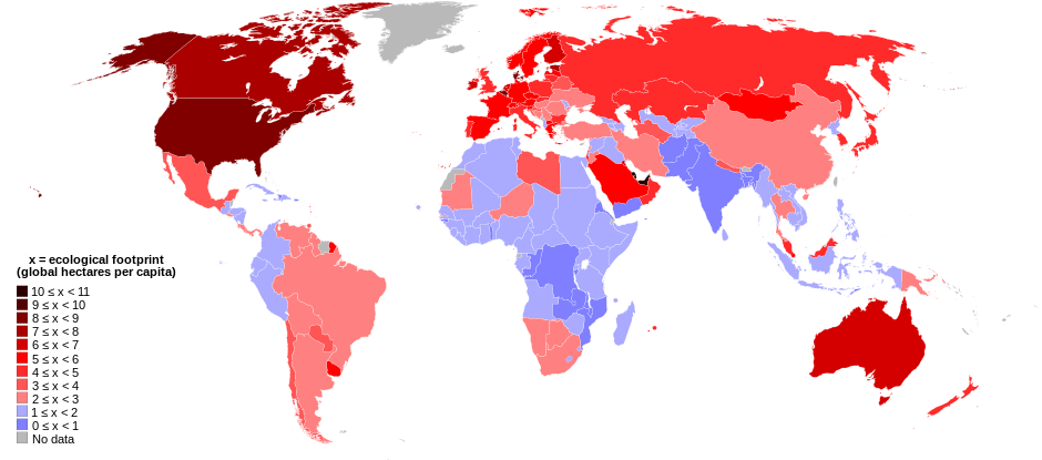
English: World map of countries shaded according to their ecological footprint in 2007 (published on 13 October 2010 by the Global Footprint Network). It is measured by the amount of global hectares that are affected by humans per capita of the country. Lighter shades denote countries with a lower ecological footprint per capita and darker shaded for countries with a higher ecological footprint per capita. The total ecological footprint (global hectares affected by humans) is measured as a total of six factors: cropland footprint, grazing footprint, forest footprint, fishing ground footprint, carbon footprint and built-up land.
Français : Mapemonde colorée selon l'empreinte écologique moyenne des habitants de chaque pays, exprimée en ha par personne, en 2007. Le tons plus chairs correspondent à une empreinte faible, les tons plus sombres à une empreinte plus forte. Six facteurs sont pris en compte pour mesurer cette empreinte: L'agriculture, le pâturage, l'exploitation forestière, la pêche, la production de carbone et l'urbanisation.
No data
0 ≤ x < 1
1 ≤ x < 2
2 ≤ x < 3
3 ≤ x < 4
4 ≤ x < 5
5 ≤ x < 6
6 ≤ x < 1
7 ≤ x < 8
8 ≤ x < 9
9 ≤ x < 10
10 ≤ x < 11 |
| Tarikh | |
| Sumber | Self-made with data from list of countries by ecological footprint. |
| Pengarang | Jolly Janner |
| Versi lain |
|


.svg)
Perlesenan
| Saya selaku pemegang hak cipta karya ini melepaskan karya ini ke dalam domain awam di seluruh dunia. Di sesetengah negara, undang-undangnya mungkin tidak mengizinkan; jika begitu: Saya memberi sesiapa sahaja hak untuk menggunakan karya ini untuk apa jua tujuan, tanpa sebarang syarat, melainkan undang-undang menetapkan syarat-syarat sedemikian. |
Sejarah fail
Klik pada tarikh/waktu untuk melihat rupa fail tersebut pada waktu itu.
| Tarikh/Waktu | Gambar kenit | Ukuran | Pengguna | Komen | |
|---|---|---|---|---|---|
| semasa | 01:24, 30 Mac 2018 | | 940 × 415 (1.36 MB) | Sisgeo | Employ a different color for countries under 2.1 gHa, the estimated limit of sustainability. |
| 18:44, 29 Oktober 2010 |  | 940 × 415 (1.68 MB) | Jolly Janner | Added a white box to represent the background | |
| 18:38, 29 Oktober 2010 |  | 940 × 415 (1.68 MB) | Jolly Janner | white background | |
| 18:36, 29 Oktober 2010 |  | 940 × 415 (1.68 MB) | Jolly Janner | white background | |
| 18:24, 29 Oktober 2010 |  | 940 × 415 (1.68 MB) | Jolly Janner | == {{int:filedesc}} == {{Information |Description={{en|1=World map of countries shaded according to their ecological footprint in 2007 (published on 13 October 2010 by the Global Footprint Network). It is measured by the amoun |
Penggunaan fail
Laman berikut menggunakan fail ini:
Penggunaan fail sejagat
Fail ini digunakan oleh wiki-wiki lain yang berikut:
- Penggunaan di ca.wikipedia.org
- Penggunaan di el.wikipedia.org
- Penggunaan di en.wikipedia.org
- Penggunaan di en.wikibooks.org
- Penggunaan di eu.wikipedia.org
- Penggunaan di fa.wikipedia.org
- Penggunaan di fr.wikipedia.org
- Penggunaan di gl.wikipedia.org
- Penggunaan di hi.wikipedia.org
- Penggunaan di it.wikipedia.org
- Penggunaan di nl.wikipedia.org
- Penggunaan di pl.wikipedia.org
- Penggunaan di pl.wikibooks.org
- Penggunaan di ro.wikipedia.org
- Penggunaan di sk.wikipedia.org
- Penggunaan di sr.wikipedia.org
- Penggunaan di ta.wikipedia.org
- Penggunaan di uk.wikipedia.org
- Penggunaan di zh.wikipedia.org
.svg)