Daerah Guro: Perbezaan antara semakan
Kandungan dihapus Kandungan ditambah
Mencipta laman baru dengan kandungan ''''{{subst:PAGENAME}}''' merupakan sebuah daerah (gu) yang terletak di kawasan Seoul, Korea Selatan. Kategori:Daerah di Korea Selatan en...' |
Tiada ringkasan suntingan |
||
| Baris 1: | Baris 1: | ||
{{Refimprove|date=September 2007}} |
|||
{{Infobox settlement |
|||
<!-- See Template:Infobox settlement for additional fields and descriptions --> |
|||
| name = Guro District |
|||
| official_name = 구로구 · 九老區 |
|||
| native_name = |
|||
| native_name_lang = kr |
|||
| settlement_type = [[List of districts of Seoul|District]] |
|||
<!-- images, nickname, motto ---> |
|||
| image_skyline = |
|||
| imagesize = |
|||
| image_alt = |
|||
| image_caption = A nightview of [[Sindorim-dong|Shindorim]] |
|||
| image_flag = |
|||
| flag_alt = |
|||
| image_seal = |
|||
| seal_alt = |
|||
| image_shield = |
|||
| shield_alt = |
|||
| image_blank_emblem = |
|||
| nickname = |
|||
| motto = |
|||
<!-- maps and coordinates ------> |
|||
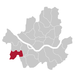
| image_map = Seoul Guro-gu.svg |
|||
| map_alt = |
|||
| map_caption = Location of Guro District in [[Seoul]] |
|||
| image_dot_map = |
|||
| dot_mapsize = |
|||
| dot_map_base_alt = |
|||
| dot_map_alt = |
|||
| dot_map_caption = |
|||
| dot_x = |dot_y = |
|||
| pushpin_map = |
|||
| pushpin_label_position = <!-- position of the pushpin label: left, right, top, bottom, none --> |
|||
| pushpin_map_alt = |
|||
| pushpin_map_caption = |
|||
| latd = |
|||
| latm = |
|||
| lats = |
|||
| latNS = |
|||
| longd = |
|||
| longm = |
|||
| longs = |
|||
| longEW = |
|||
| coor_pinpoint = <!-- to specify exact location of coordinates (was coor_type) --> |
|||
| coordinates_display = inline,title |
|||
| coordinates_footnotes = <!-- for references: use <ref> tags --> |
|||
<!-- location ------------------> |
|||
| coordinates_region = KR |
|||
| subdivision_type = [[List of sovereign states|Country]] |
|||
| subdivision_name = [[South Korea]] |
|||
| subdivision_type1 = [[List of regions of Korea|Region]] |
|||
| subdivision_name1 = [[Seoul National Capital Area|Sudogwon]] |
|||
| subdivision_type2 = [[Direct-controlled municipality#South Korea|Special City]] |
|||
| subdivision_name2 = [[Seoul]] |
|||
| subdivision_type3 = Administrative dong |
|||
| subdivision_name3 = 15 |
|||
<!-- established ---------------> |
|||
| established_title = <!-- Settled --> |
|||
| established_date = |
|||
| founder = |
|||
| named_for = |
|||
<!-- seat, smaller parts -------> |
|||
| seat_type = <!-- defaults to: Seat --> |
|||
| seat = |
|||
<!-- government type, leaders --> |
|||
| government_footnotes = <!-- for references: use <ref> tags --> |
|||
| leader_party = |
|||
| leader_title = |
|||
| leader_name = |
|||
| leader_title1 = |
|||
| leader_name1 = <!-- etc., up to leader_title4 / leader_name4 --> |
|||
<!-- display settings ---------> |
|||
| total_type = <!-- to set a non-standard label for total area and population rows --> |
|||
| unit_pref = <!-- enter: Imperial, to display imperial before metric --> |
|||
<!-- area ----------------------> |
|||
| area_magnitude = <!-- use only to set a special wikilink --> |
|||
| area_footnotes = <!-- for references: use <ref> tags --> |
|||
| area_total_km2 = 20.11 |
|||
| area_total_sq_mi = <!-- see table @ Template:Infobox settlement for details --> |
|||
| area_land_km2 = |
|||
| area_land_sq_mi = |
|||
| area_water_km2 = |
|||
| area_water_sq_mi = |
|||
| area_water_percent = |
|||
| area_note = |
|||
<!-- elevation -----------------> |
|||
| elevation_footnotes = <!-- for references: use <ref> tags --> |
|||
| elevation_m = |
|||
| elevation_ft = |
|||
<!-- population ----------------> |
|||
| population_footnotes = |
|||
| population_total = 417,339 |
|||
| population_as_of = 2010<ref name="kosispop">[http://kosis.kr/abroad/abroad_01List.jsp?parentId=A Korean Statistical Information Service (Korean) > Population and Household > Census Result (2010) > Population by Administrative district, Sex and Age / Alien by Administrative district and Sex], Retrieved 2010-06-02.</ref> |
|||
| population_density_km2 = auto |
|||
| population_density_sq_mi= |
|||
| population_est = |
|||
| pop_est_as_of = |
|||
| population_demonym = <!-- demonym, ie. Liverpudlian for someone from Liverpool --> |
|||
| population_note = |
|||
<!-- time zone(s) --------------> |
|||
| timezone1 = [[Korea Standard Time]] |
|||
| utc_offset1 = +9 |
|||
| timezone1_DST = |
|||
| utc_offset1_DST = |
|||
<!-- postal codes, area code ---> |
|||
| postal_code_type = <!-- enter ZIP code, Postcode, Post code, Postal code... --> |
|||
| postal_code = |
|||
| area_code_type = <!-- defaults to: Area code(s) --> |
|||
| area_code = |
|||
<!-- website, footnotes --------> |
|||
| website = [http://english.guro.go.kr/ Guro-gu official website] |
|||
| footnotes = |
|||
}} |
|||
'''Daerah Guro''' merupakan sebuah [[daerah]] (gu) yang terletak di kawasan [[Seoul]], [[Korea Selatan]]. |
'''Daerah Guro''' merupakan sebuah [[daerah]] (gu) yang terletak di kawasan [[Seoul]], [[Korea Selatan]]. |
||
Semakan pada 13:59, 5 Januari 2013
Guro District | |
|---|---|
| 구로구 · 九老區 | |
 Location of Guro District in Seoul | |
| Country | South Korea |
| Region | Sudogwon |
| Special City | Seoul |
| Administrative dong | 15 |
| Keluasan | |
| • Jumlah | 20.11 km2 (7.76 batu persegi) |
| Penduduk (2010[1]) | |
| • Jumlah | 417,339 |
| • Kepadatan | 21,000/km2 (54,000/batu persegi) |
| Zon waktu | UTC+9 (Korea Standard Time) |
| Laman sesawang | Guro-gu official website |
Daerah Guro merupakan sebuah daerah (gu) yang terletak di kawasan Seoul, Korea Selatan.
