
Fail:Longshore i18n.png

Saiz pralihat ini: 389 × 599 piksel. Leraian-leraian lain: 156 × 240 piksel | 311 × 480 piksel | 653 × 1,006 piksel.
Fail asli (653 × 1,006 piksel, saiz fail: 31 KB, jenis MIME: image/png)
Ringkasan
| Keterangan |
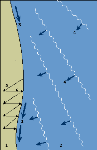
internationalization of the Longshore drift diagram. |
||
| Sumber | http://commons.wikimedia.org/wiki/Image:Longshore.gif | ||
| Pengarang | USGS/USGov, modified by Eurico Zimbres | ||
| Kebenaran (Penggunaan semula fail ini) |
Free for all use | ||
| Versi lain |
|

Perlesenan
This work is in the public domain in the United States because it is a work prepared by an officer or employee of the United States Government as part of that person’s official duties under the terms of Title 17, Chapter 1, Section 105 of the US Code.
Note: This only applies to original works of the Federal Government and not to the work of any individual U.S. state, territory, commonwealth, county, municipality, or any other subdivision. This template also does not apply to postage stamp designs published by the United States Postal Service since 1978. (See § 313.6(C)(1) of Compendium of U.S. Copyright Office Practices). It also does not apply to certain US coins; see The US Mint Terms of Use.
|
 | |
| Fail ini telah dikenal pasti sebagai bebas daripada sekatan-sekatan yang dikenali mengikut undang-undang hak cipta, termasuk semua hak berkaitan dan berjiran. | ||
Sejarah fail
Klik pada tarikh/waktu untuk melihat rupa fail tersebut pada waktu itu.
| Tarikh/Waktu | Gambar kenit | Ukuran | Pengguna | Komen | |
|---|---|---|---|---|---|
| semasa | 14:47, 31 Mei 2006 | | 653 × 1,006 (31 KB) | Zimbres | {{Information |Description=internationalization of the Longshore drift diagram.<br> '''1'''=beach<br> '''2'''=sea<br> '''3'''=longshore current direction<br> '''4'''=incoming waves<br> '''5'''=swash<br> '''6'''=backwash <br> |Source=http://commons.wikime |
Penggunaan fail
Laman berikut menggunakan fail ini:
Penggunaan fail sejagat
Fail ini digunakan oleh wiki-wiki lain yang berikut:
- Penggunaan di cy.wikipedia.org
- Penggunaan di en.wikipedia.org
- Penggunaan di fa.wikipedia.org
- Penggunaan di fr.wikipedia.org
- Penggunaan di id.wikipedia.org
- Penggunaan di lt.wikipedia.org
- Penggunaan di simple.wikipedia.org
- Penggunaan di tr.wikipedia.org
- Penggunaan di zh.wikipedia.org