
Fail:Premongol.png
Tiada leraian lebih besar.
Premongol.png (752 × 590 piksel, saiz fail: 31 KB, jenis MIME: image/png)
Ringkasan

|
This map has been uploaded by Electionworld from en.wikipedia.org to enable the |
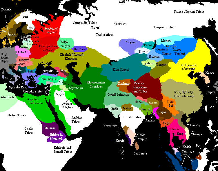
Eurasia on the eve of the Mongol invasions, c. 1200 CE. Source unknown. All of Central, North and East Asian states and tribes were located in wrong places.

|
This historical map image could be re-created using vector graphics as an SVG file. This has several advantages; see Commons:Media for cleanup for more information. If an SVG form of this image is available, please upload it and afterwards replace this template with
{{vector version available|new image name}}.
It is recommended to name the SVG file “Premongol.svg”—then the template Vector version available (or Vva) does not need the new image name parameter. |
Perlesenan

|
Kebenaran diberikan untuk menyalin, mengedar dan/atau mengubah dokumen ini di bawah syarat-syarat Lesen Pendokumenan Bebas GNU, versi 1.2 atau mana-mana versi selepas ini, yang diterbitkan oleh Yayasan Perisian Bebas; tanpa Seksyen yang Tak Berubah, tanpa Teks Kulit Depan dan tanpa Teks Kulit Belakang. Salinan lesen ini boleh didapati dalam seksyen yang bertajuk Lesen Pendokumenan Bebas GNU". |
| Fail ini dilesenkan di bawah lesen Pengiktirafan-Perkongsian Serupa 3.0 Tidak Diport Creative Commons. | ||
| ||
| Tag pelesenan ini dibubuh pada fail ini sebagai sebahagian kemas kini pelesenan GFDL |
See also

Original upload notes
20:43, 21 November 2006 . . Timmie.merc (talk | contribs | block) 752 × 590 (31,383 bytes) (Reverted to earlier revision)
20:42, 21 November 2006 . . Timmie.merc (talk | contribs | block) 752 × 590 (31,383 bytes) (Reverted to earlier revision)
17:31, 3 October 2006 . . Vilniškis (talk | contribs | block) 752 × 590 (31,383 bytes) (Eurasia on the eve of the Mongol invasions, c. 1200.)
17:26, 3 October 2006 . . Vilniškis (talk | contribs | block) 752 × 590 (31,383 bytes)
18:11, 26 September 2006 . . Nanshu (talk | contribs | block) 752 × 590 (20,501 bytes) (minor corrections on East Asia)
20:35, 6 June 2006 . . Foobaz (talk | contribs | block) 752 × 590 (20,505 bytes) (Changed name of Vietnam from Annam to Đại Việt as talk page suggested.)
12:26, 1 June 2006 . . Foobaz (talk | contribs | block) 752 × 590 (20,469 bytes) (fixed spelling error in Africa: "Berber Trubes" -> "Berber Tribes")
00:26, 14 January 2006 . . Briangotts (talk | contribs | block) 752 × 590 (45,292 bytes) (Eurasia on the eve of the Mongol invasions, c. 1200 CE. Category:Historical maps by User:Briangotts)
10:42, 22 December 2005 . . Briangotts (talk | contribs | block) 752 × 590 (44,927 bytes) (Eurasia on the eve of the Mongol invasions, c. 1200 CE. Category:Historical maps by User:Briangotts)
| Annotations | This image is annotated: View the annotations at Commons |
Sejarah fail
Klik pada tarikh/waktu untuk melihat rupa fail tersebut pada waktu itu.
| Tarikh/Waktu | Gambar kenit | Ukuran | Pengguna | Komen | |
|---|---|---|---|---|---|
| semasa | 13:27, 29 September 2019 | | 752 × 590 (31 KB) | Бмхүн | incorrect{{DEFAULTSORT:<noinclude></noinclude>}} |
| 19:04, 22 November 2018 |  | 752 × 590 (31 KB) | Spiridon Ion Cepleanu | Reverted to version as of 19:35, 27 March 2014 (UTC) | |
| 20:59, 8 Mac 2015 |  | 3,240 × 1,903 (6.82 MB) | Spiridon Ion Cepleanu | Modification after discussion with Khorichar and verifications in the Westermann Grosser Atlas zur Weltgeschichte (H.E.Stier, dir.), 1985. Perhaps new ameliorations may be tried. | |
| 14:49, 3 Mac 2015 |  | 752 × 590 (24 KB) | Spiridon Ion Cepleanu | New precisions according with Khorichar's rectifications [https://commons.wikimedia.org/wiki/User_talk:Khorichar] | |
| 17:40, 11 Disember 2014 |  | 752 × 590 (24 KB) | Spiridon Ion Cepleanu | Some little details according with H.E.Stier (dir.) « Grosser Atlas zur Weltgeschichte », Westermann 1985, ISBN 3-14-100919-8, « Putzger historischer Weltatlas Cornelsen » 1990, ISBN 3-464-00176-8 & some other works. | |
| 19:35, 27 Mac 2014 |  | 752 × 590 (31 KB) | Comnenus | Reverted to version as of 06:43, 5 March 2012 | |
| 11:44, 4 Ogos 2012 |  | 752 × 590 (31 KB) | محک | Tabaristan was Fals. | |
| 06:43, 5 Mac 2012 |  | 752 × 590 (31 KB) | Ecthelion83 | 1. Added more geographical accuracy to Korean Peninsula 2. Cleaned up some of the artifacts from previous edits (i.e. spots of wrong color) 3. This map is meant to depict the Old World prior to the rise of the Mongol Empire, i.e. before the year 1190, ... | |
| 06:43, 5 Mac 2012 |  | 752 × 590 (137 KB) | Ecthelion83 | 1. Added more geographical accuracy to Korean Peninsula 2. Cleaned up some of the artifacts from previous edits (i.e. spots of wrong color) 3. This map is meant to depict the Old World prior to the rise of the Mongol Empire, i.e. before the year 1190, ... | |
| 14:44, 21 September 2011 |  | 752 × 590 (137 KB) | Comnenus | Reverted to version as of 18:29, 20 August 2011 Venice did not rule those territories in 1200. |
Penggunaan fail
Tiada laman yang menggunakan fail ini.
Penggunaan fail sejagat
Fail ini digunakan oleh wiki-wiki lain yang berikut:
- Penggunaan di ar.wikipedia.org
- Penggunaan di azb.wikipedia.org
- Penggunaan di ca.wikipedia.org
- Penggunaan di de.wikipedia.org
- Penggunaan di de.wikiversity.org
- Penggunaan di en.wikipedia.org
- Penggunaan di en.wikibooks.org
- Penggunaan di es.wikipedia.org
- Penggunaan di et.wikipedia.org
- Penggunaan di fa.wikipedia.org
- Penggunaan di fr.wikipedia.org
- Penggunaan di hi.wikipedia.org
- Penggunaan di it.wikipedia.org
- Penggunaan di mn.wikipedia.org
- Penggunaan di pnb.wikipedia.org
- Penggunaan di ru.wikipedia.org
- Penggunaan di ta.wikipedia.org
- Penggunaan di tl.wikipedia.org
- Penggunaan di www.wikidata.org