
Fail:Carte Lewis and Clark Expedition.png
Saiz pralihat ini: 800 × 520 piksel. Leraian-leraian lain: 320 × 208 piksel | 640 × 416 piksel | 1,024 × 665 piksel | 1,513 × 983 piksel.
Fail asli (1,513 × 983 piksel, saiz fail: 84 KB, jenis MIME: image/png)

|
This historical map image could be re-created using vector graphics as an SVG file. This has several advantages; see Commons:Media for cleanup for more information. If an SVG form of this image is available, please upload it and afterwards replace this template with
{{vector version available|new image name}}.
It is recommended to name the SVG file “Carte Lewis and Clark Expedition.svg”—then the template Vector version available (or Vva) does not need the new image name parameter. |
Ringkasan
| Keterangan |
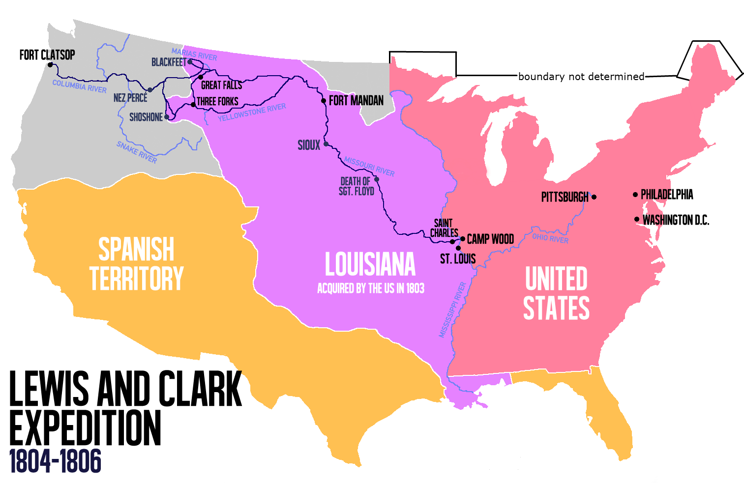
English: Route of the Lewis and Clark Expedition |
| Tarikh | |
| Sumber |
Karya sendiri, This file was derived from: Carte Lewis-Clark Expedition-en.png |
| Pengarang | Victor van Werkhooven |
| Versi lain |
 |
Perlesenan
| Saya selaku pemegang hak cipta karya ini melepaskan karya ini ke dalam domain awam di seluruh dunia. Di sesetengah negara, undang-undangnya mungkin tidak mengizinkan; jika begitu: Saya memberi sesiapa sahaja hak untuk menggunakan karya ini untuk apa jua tujuan, tanpa sebarang syarat, melainkan undang-undang menetapkan syarat-syarat sedemikian. |
Sejarah fail
Klik pada tarikh/waktu untuk melihat rupa fail tersebut pada waktu itu.
| Tarikh/Waktu | Gambar kenit | Ukuran | Pengguna | Komen | |
|---|---|---|---|---|---|
| semasa | 14:21, 13 Jun 2014 | | 1,513 × 983 (84 KB) | Nwbeeson | Reverted to version as of 14:18, 13 June 2014 |
| 14:20, 13 Jun 2014 |  | 1,513 × 983 (84 KB) | Nwbeeson | Corrected boundary of the United States. The original left out Maine, Michigan, Wisconsin, and part of Minnesota, none of which were states, but all of which were definitely part of the territory of the United States. | |
| 14:18, 13 Jun 2014 |  | 1,513 × 983 (84 KB) | Nwbeeson | Corrected boundary of the United States. The original left out Maine, Michigan, Wisconsin, and part of Minnesota, none of which were states, but all of which were definitely part of the territory of the United States. | |
| 15:17, 22 Mei 2014 |  | 1,513 × 983 (134 KB) | Luctor | User created page with UploadWizard |
Penggunaan fail
Laman berikut menggunakan fail ini:
Penggunaan fail sejagat
Fail ini digunakan oleh wiki-wiki lain yang berikut:
- Penggunaan di ast.wikipedia.org
- Penggunaan di bn.wikipedia.org
- Penggunaan di de.wikipedia.org
- Penggunaan di en.wikipedia.org
- Penggunaan di es.wikipedia.org
- Penggunaan di et.wikipedia.org
- Penggunaan di eu.wikipedia.org
- Penggunaan di fa.wikipedia.org
- Penggunaan di gl.wikipedia.org
- Penggunaan di hu.wikipedia.org
- Penggunaan di it.wikipedia.org
- Penggunaan di ko.wikipedia.org
- Penggunaan di nl.wikipedia.org
- Penggunaan di no.wikipedia.org
- Penggunaan di oc.wikipedia.org
- Penggunaan di pl.wikipedia.org
- Penggunaan di sr.wikipedia.org
- Penggunaan di tr.wikipedia.org
- Penggunaan di www.wikidata.org
- Penggunaan di zh.wikipedia.org