
Fail:South Island 2007-12-07.jpg
Fail asli (3,000 × 3,800 piksel, saiz fail: 1.67 MB, jenis MIME: image/jpeg)
Ringkasan
| Keterangan |
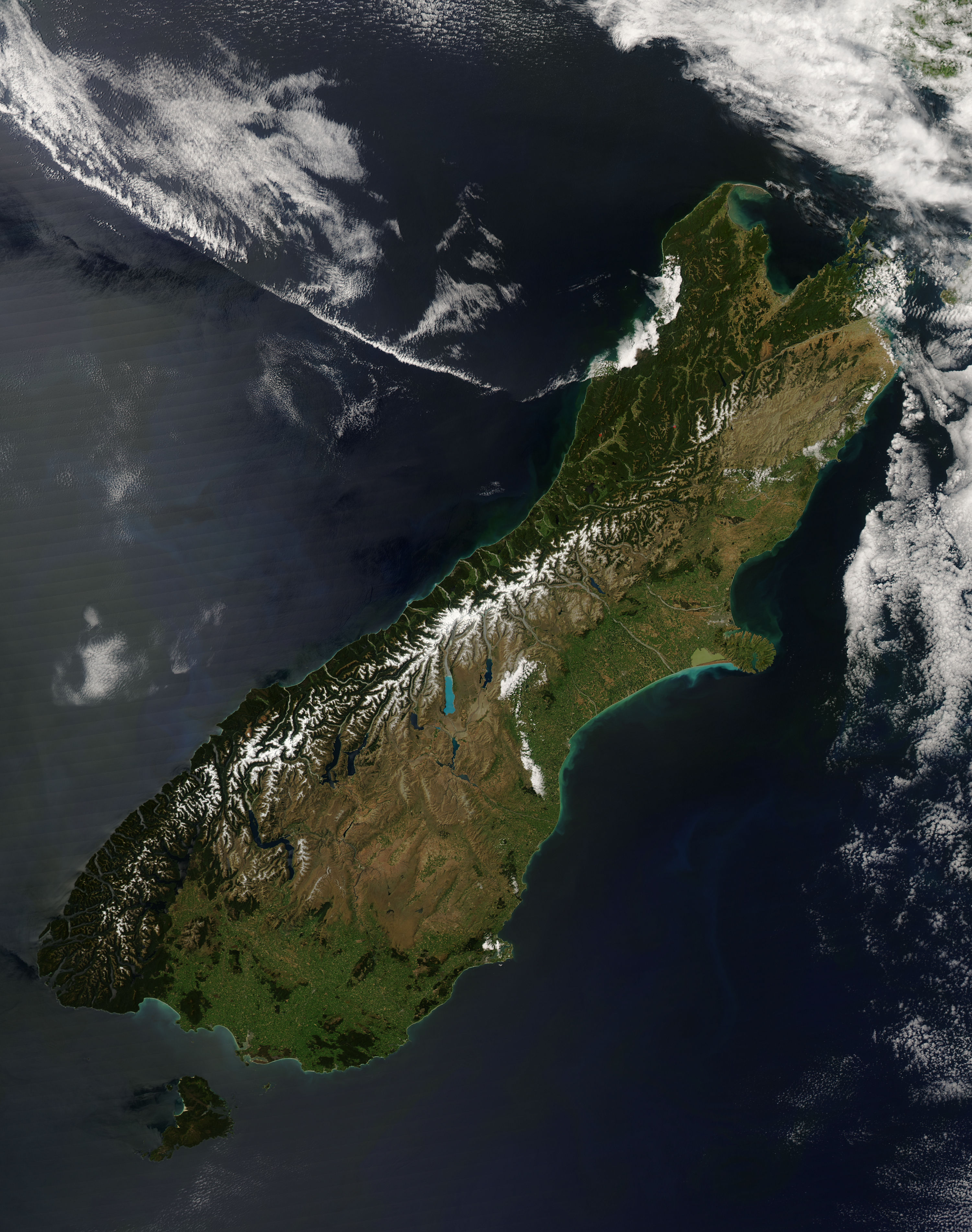
This image provides a nearly cloud-free view of the South Island of New Zealand, from the Moderate Resolution Imaging Spectroradiometer (MODIS) on NASA’s Aqua satellite. From Earth Observatory website: Colors ranging from deep brown to stark white give New Zealand’s South Island its intense beauty. The snow-capped Southern Alps run down the northern shore of the island. The highest peak in the range (and in New Zealand) is Aoraki/Mount Cook at 3,754 meters (12,316 ft). The mountains are rising as the Pacific Plate, the section of the Earth’s crust that holds the Pacific Ocean, including parts of New Zealand’s South Island, sinks beneath the Australia Plate, which holds the rest of New Zealand. The collision between the two plates pushes the mountains up and fosters volcanoes on the country’s North Island. Not only do the mountains mark the line between two tectonic plates, they also create different climate regions, which are visible in the image. The shoreline west of the mountains receives more rain than any other place in the South Island. The rain-drenched shoreline is deep green, covered by temperature rain forests. To the south, the shore turns dark brown where rocky mountain terrain extends to the Pacific Ocean. Fingers of water cut into the western shore where glaciers cut deep fjords over time. The landscape on the east side of the mountains is dramatically different. Hidden in the rain shadow of the Southern Alps, the region receives less rain than its neighbor and is correspondingly tan instead of green. The dry landscape is punctuated by alpine glacier lakes that hang like sapphire and aquamarine pendants from the mountain chain. Rivers also drain melting snow from the south side of the mountains into the Pacific Ocean. Over eons, the rivers have deposited finely ground rock from the mountains onto the landscape below, building nutrient-rich alluvial plains. Sediment washing into the ocean colors the water green blue. Spots of bright green accentuate the plains, an indication that these regions are cultivated. The large image reveals the grid of green made by fields of crops across the plains. The Moderate Resolution Imaging Spectroradiometer (MODIS) on NASA’s Aqua satellite captured this photo-like image of the South Island on December 7, 2007, as spring began to give way to summer in this southern location. Places where the sensor detected fire are marked with red circles. The large image has a resolution of 250 meters per pixel, the highest resolution image available. The MODIS Rapid Response System provides the image in additional resolutions. NASA image courtesy Jeff Schmaltz, MODIS Rapid Response Team at NASA GSFC |
| Tarikh | |
| Sumber | [1], with description at NASA's Earth Observatory |
| Pengarang | Jeff Schmaltz, MODIS Rapid Response Team at NASA GSFC |
| Kebenaran (Penggunaan semula fail ini) |
Public domain - original work of NASA |
![[1]](http://rapidfire.sci.gsfc.nasa.gov/gallery/?2007341-1207/NewZealand.A2007341.0240.250m.jpg)
Perlesenan
| This file is in the public domain in the United States because it was solely created by NASA. NASA copyright policy states that "NASA material is not protected by copyright unless noted". (See Template:PD-USGov, NASA copyright policy page or JPL Image Use Policy.) | ||
 |
Warnings:
|
Sejarah fail
Klik pada tarikh/waktu untuk melihat rupa fail tersebut pada waktu itu.
| Tarikh/Waktu | Gambar kenit | Ukuran | Pengguna | Komen | |
|---|---|---|---|---|---|
| semasa | 13:32, 26 Disember 2007 | | 3,000 × 3,800 (1.67 MB) | Avenue | == Summary == {{Information| |Description= This true-color image provides a nearly cloud-free look at the South Island of New Zealand, from NASA’s Terra satellite. |Source=[http://rapidfire.sci.gsfc.nasa.gov/gallery/?2007341-1207/NewZealand.A2007341.024 |
Penggunaan fail
Laman berikut menggunakan fail ini:
Penggunaan fail sejagat
Fail ini digunakan oleh wiki-wiki lain yang berikut:
- Penggunaan di bg.wikipedia.org
- Penggunaan di cs.wikipedia.org
- Penggunaan di dsb.wikipedia.org
- Penggunaan di en.wikipedia.org
- Penggunaan di gl.wikipedia.org
- Penggunaan di hsb.wikipedia.org
- Penggunaan di hu.wikipedia.org
- Penggunaan di ja.wikipedia.org
- Penggunaan di ka.wikipedia.org
- Penggunaan di pl.wikipedia.org
- Penggunaan di pl.wiktionary.org
- Penggunaan di pt.wikipedia.org
- Penggunaan di ta.wikipedia.org