
Fail:Czechoslovakia I.png
Saiz pralihat ini: 800 × 364 piksel. Leraian-leraian lain: 320 × 146 piksel | 640 × 291 piksel | 1,128 × 513 piksel.
Fail asli (1,128 × 513 piksel, saiz fail: 66 KB, jenis MIME: image/png)
| Keterangan |
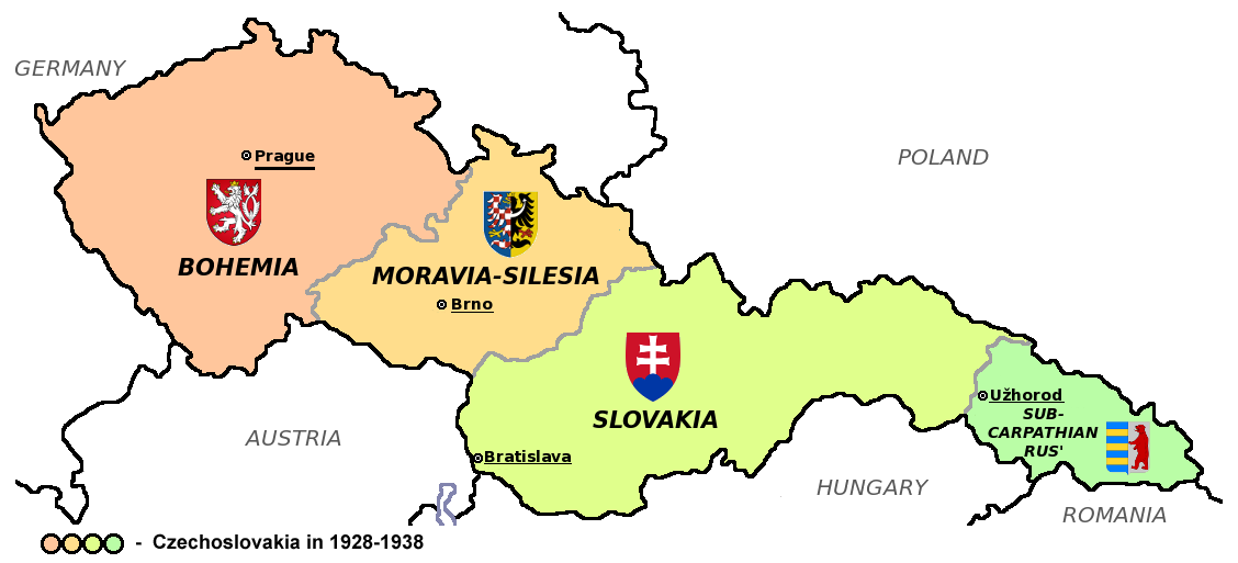
Čeština: Zemská mapa Československa v letech 1928 až 1938 s vyznačenými zemskými hlavními městy a znaky jednotlivých zemí English: Maps of Czechoslovakia in 1928-1938 with marked borders of all four Czechoslovak countries and their coats of arms and regional capital cities
Based on Image:Czechoslovakia_COA_medium.svg. * |
| Tarikh | (UTC) |
| Sumber | |
| Pengarang | |
| Versi lain |
Derivative works of this file: |
| Ini adalah gambar sentuh, ini bermakna bahawa ia telah didigitalkan dari versi asal. Modifikasi: Simplified map. Versi asal boleh dilihat di sini: CarpathianRutheniaCoA.svg. Modifications made by Millenium187.
|
Fail ini dilesenkan di bawah lesen Pengiktirafan-Perkongsian Serupa 3.0 Tidak Diport Creative Commons.
- Anda bebas:
- untuk berkongsi – untuk menyalin, mengedar dan memindah hasil kerja
- untuk mencampur semula – untuk menyesuaikan karya
- Di bawah syarat berikut:
- pengiktirafan – Anda mesti memberi penghargaan yang berpatutan, bekalkan pautan ke lesen, dan tunjukkan jika perubahan telah dibuat. Anda boleh lakukannya dalam sebarang cara yang munasabah, tetapi bukan dalam sebarang cara yang mencadangkan pemberi lesen mengendors anda atau penggunaan anda.
- perkongsian serupa – Jika anda mengubah, adun semula, atau menokok tambah bahan, anda mesti menyebarkan sumbangan anda di bawah lesen yang sama atau serasi dengan yang asal.
Log muat naik asal
This image is a derivative work of the following images:
- File:Czechoslovakia01.png licensed with PD-self
- 2011-05-19T10:54:48Z PANONIAN 1128x513 (64020 Bytes) minor change, marked provincial capitals
- 2011-05-17T09:53:27Z PANONIAN 1128x513 (63994 Bytes) Reverted to version as of 10:38, 24 April 2011 - because this is map of Czechoslovakia and it was capital of Czechoslovakia
- 2011-05-17T05:07:38Z Millenium187 1128x513 (56086 Bytes) Why was Prague underlined and Vienna, Brno, Bratislava and other capital cities were not? -- corrected
- 2011-04-24T10:38:30Z PANONIAN 1128x513 (63994 Bytes) few corrections
- 2011-04-23T11:31:49Z PANONIAN 1128x509 (62348 Bytes) improved version
- 2008-12-20T20:58:14Z Kirk 1100x497 (80038 Bytes) {{Information |Description= |Source= |Date= |Author= |Permission= |other_versions= }}
- 2006-12-28T16:11:35Z Electionworld 1100x497 (92110 Bytes) {{ew|en|PANONIAN}} Map of {{link|Czechoslovakia}} (self made) Note: The provinces shown on the map were introduced by Act No. 125/1927 Zb. and became effective in 1928. {{PD-self}} [[Category:Maps of Czechoslovakia]] [[Cat
- File:Small_coat_of_arms_of_the_Czech_Republic2.png licensed with PD-self
- 2006-07-18T15:34:18Z Poznaniak 486x594 (126651 Bytes) {{Information |Description=Godło Czech |Source=własna praca |Date=18.07.2006 |Author=[[:user:Poznaniak|Poznaniak]] |Permission= }}
- File:Moravia-Silesia.png licensed with PD-self
- 2010-07-25T21:44:29Z RgC 490x600 (65918 Bytes) {{Information |Description={{en|1=Joint of coat of arms of Moravia and Silesia.}} |Source={{own}} |Author=[[User:RgC|RgC]] |Date=2010-07-25 |Permission= |other_versions= }} [[Category:User page images]]
- File:Coat_of_arms_of_Slovakia.svg licensed with Cc-by-sa-3.0-migrated, GFDL
- 2006-06-06T21:41:47Z Tlusťa 400x500 (4623 Bytes) ==Summary== {{Information |Description={{en|Coat of arms of the [[Slovakia]].}} {{cs|Znak [[:cs:Slovensko|Slovenska]].}} |Source= |Date= |Author=[[User:Tlusťa|Tlusťa]] |Permission= |other_versions= }} ==Licensing == {{GFDL
- File:CarpathianRutheniaCoA.svg licensed with Cc-pd-mark-footer, PD-old
- 2007-06-01T16:53:20Z DDima 325x394 (27235 Bytes) fix colors
- 2006-11-08T06:35:05Z Happenstance 325x394 (27214 Bytes) created
Uploaded with derivativeFX
| Annotations | This image is annotated: View the annotations at Commons |
Sejarah fail
Klik pada tarikh/waktu untuk melihat rupa fail tersebut pada waktu itu.
| Tarikh/Waktu | Gambar kenit | Ukuran | Pengguna | Komen | |
|---|---|---|---|---|---|
| semasa | 18:40, 12 Ogos 2011 | | 1,128 × 513 (66 KB) | Millenium187 | {{Information |Description={{cs|Zemská mapa Československa v letech 1928 až 1938 s vyznačenými zemskými hlavními městy a znaky jednotlivých zemí}} {{en|Maps of Czechoslovakia in 1928-1938 with marked borders of all four Czechoslovak countries a |
Penggunaan fail
Tiada laman yang menggunakan fail ini.
Penggunaan fail sejagat
Fail ini digunakan oleh wiki-wiki lain yang berikut:
- Penggunaan di azb.wikipedia.org
- Penggunaan di az.wikipedia.org
- Penggunaan di bn.wikipedia.org
- Penggunaan di da.wikipedia.org
- Penggunaan di de.wikipedia.org
- Penggunaan di el.wikipedia.org
- Penggunaan di en.wikipedia.org
- Penggunaan di es.wikipedia.org
- Penggunaan di he.wikipedia.org
- Penggunaan di io.wikipedia.org
- Penggunaan di mk.wikipedia.org
- Penggunaan di sq.wikipedia.org
- Penggunaan di te.wikipedia.org
- Penggunaan di th.wikipedia.org
- Penggunaan di tr.wikipedia.org
- Penggunaan di uk.wikipedia.org