
Fail:Nagorno-Karabakh conflict map (pre-2020).png
Saiz pralihat ini: 800 × 400 piksel. Leraian-leraian lain: 320 × 160 piksel | 640 × 320 piksel | 1,000 × 500 piksel.
Fail asli (1,000 × 500 piksel, saiz fail: 130 KB, jenis MIME: image/png)
.png)

|
This map image could be re-created using vector graphics as an SVG file. This has several advantages; see Commons:Media for cleanup for more information. If an SVG form of this image is available, please upload it and afterwards replace this template with
{{vector version available|new image name}}.
It is recommended to name the SVG file “Nagorno-Karabakh conflict map (pre-2020).svg”—then the template Vector version available (or Vva) does not need the new image name parameter. |
Ringkasan
| Keterangan |
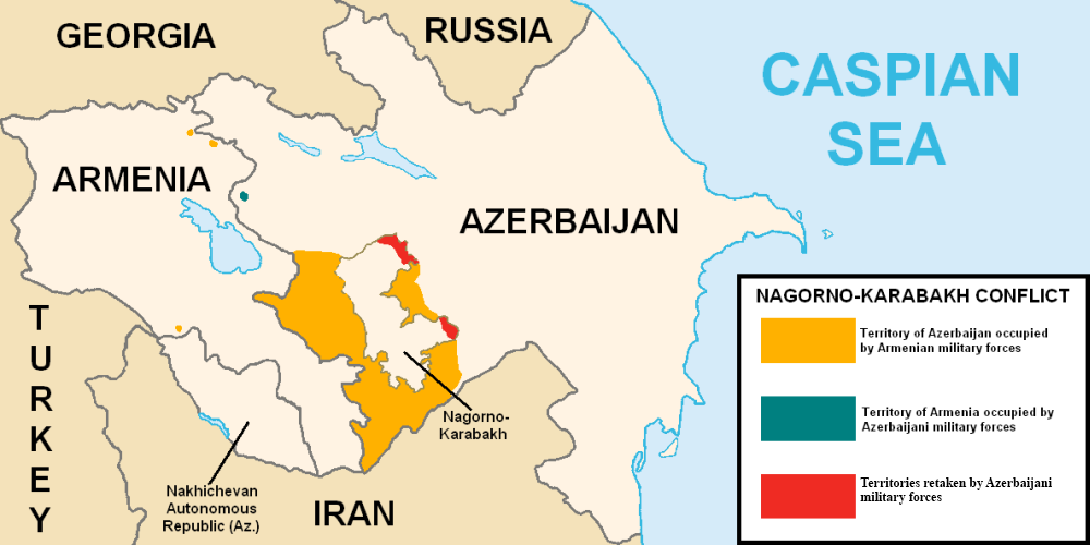
English: This map describes the situation in the disputed Nagorno-Karabakh region prior to the 2020 war. The region is internationally recognized as part of Azerbaijan but partly governed by the de facto independent Republic of Artsakh. The image is a modified version of MarshallBagramyan's map. |
| Tarikh | |
| Sumber | File:Artsakh Occupation Map.png |
| Pengarang | Elnur Hajiyev |
Perlesenan
| Elnurvl selaku pemegang hak cipta karya ini melepaskan karya ini ke dalam domain awam di seluruh dunia. Di sesetengah negara, undang-undangnya mungkin tidak mengizinkan; jika begitu: |
Sejarah fail
Klik pada tarikh/waktu untuk melihat rupa fail tersebut pada waktu itu.
| Tarikh/Waktu | Gambar kenit | Ukuran | Pengguna | Komen | |
|---|---|---|---|---|---|
| semasa | 01:18, 7 Ogos 2020 | | 1,000 × 500 (130 KB) | Elnurvl | Uploaded a work by Marshall Bagramyan from https://en.wikipedia.org/wiki/File:Artsakh_Occupation_Map.png with UploadWizard |
Penggunaan fail
Tiada laman yang menggunakan fail ini.
Penggunaan fail sejagat
Fail ini digunakan oleh wiki-wiki lain yang berikut:
- Penggunaan di en.wikipedia.org
- Penggunaan di es.wikipedia.org
- Penggunaan di eu.wikipedia.org
- Penggunaan di ga.wikipedia.org
- Penggunaan di he.wikipedia.org
- Penggunaan di pt.wikipedia.org
- Penggunaan di ru.wikipedia.org
- Penggunaan di sr.wikipedia.org
.png)