
Fail:First Manassas map2.jpg

Saiz pralihat ini: 611 × 599 piksel. Leraian-leraian lain: 245 × 240 piksel | 489 × 480 piksel | 783 × 768 piksel | 1,044 × 1,024 piksel | 2,088 × 2,048 piksel | 4,750 × 4,660 piksel.
Fail asli (4,750 × 4,660 piksel, saiz fail: 14.75 MB, jenis MIME: image/jpeg)
|
| Keterangan |
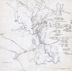
English: Confederate map from the American Civil War of First Manassas (First Battle of Bull Run). Includes some troop positions, and lists of Confederate regiments engaged in the battle of Manassas, with the names of their commanders. Relief shown by hachures. Digitized from Pen-and-ink and pencil manuscript on tracing linen, mounted on paper (original 41cm x 41cm). Scale [1:63,360]. Restored version of File:First Manassas map.jpg. Dirt, stains, and water damage removed. Various local brightness adjustments. Levels adjusted and colors balanced. |
| Tarikh | |
| Sumber | http://hdl.loc.gov/loc.gmd/g3884m.cwh00086, Library of Congress |
| Pengarang | Unknown author |
| Versi lain |
|

| Open this image as an overlay in Google Earth (Google Maps, Bing) | (Help|Source) |
This work is in the public domain in the United States because it was published (or registered with the U.S. Copyright Office) before January 1, 1929.
Public domain works must be out of copyright in both the United States and in the source country of the work in order to be hosted on the Commons. If the work is not a U.S. work, the file must have an additional copyright tag indicating the copyright status in the source country.
Note: This tag should not be used for sound recordings. |
Sejarah fail
Klik pada tarikh/waktu untuk melihat rupa fail tersebut pada waktu itu.
| Tarikh/Waktu | Gambar kenit | Ukuran | Pengguna | Komen | |
|---|---|---|---|---|---|
| semasa | 08:14, 31 Januari 2009 | | 4,750 × 4,660 (14.75 MB) | Durova | minor tweaks |
| 06:22, 31 Januari 2009 |  | 4,750 × 4,660 (14.75 MB) | Durova | {{Information |Description=Confederate map from the American Civil War of First Manassas (First Battle of Bull Run). Includes some troop positions, and lists of Confederate regiments engaged in the battle of Manassas, with the names of their commanders. |
Penggunaan fail
Laman berikut menggunakan fail ini:
Penggunaan fail sejagat
Fail ini digunakan oleh wiki-wiki lain yang berikut:
- Penggunaan di ar.wikipedia.org
- Penggunaan di en.wikipedia.org
- Portal:American Civil War
- Hachure map
- Talk:First Battle of Bull Run/Archive 1
- Wikipedia:Featured pictures thumbs/15
- Wikipedia:Featured picture candidates/First Battle of Manassas map
- Wikipedia:Featured picture candidates/February-2009
- Wikipedia:Wikipedia Signpost/2009-02-08/Features and admins
- Wikipedia:WikiProject Military history/Showcase
- Wikipedia:WikiProject Military history/Showcase/FP
- User talk:Durova/Archive 65
- Template:POTD/2010-07-21
- User:Durova/2009 MILHIST project work
- Wikipedia:Picture of the day/July 2010
- User:Durova/Featured picture gallery/2009
- Wikipedia:WikiProject United States/Recognized content
- Wikipedia:WikiProject United States/Quality content
- Wikipedia:Featured pictures/History/American Civil War
- User talk:Roger Davies/Archive 2009
- Wikipedia:Wikipedia Signpost/2009-02-08/SPV
- Portal:American Civil War/Featured picture
- Wikipedia:WikiProject United States/Featured pictures
- Wikipedia:Wikipedia Signpost/Single/2009-02-08
- Penggunaan di es.wikipedia.org
- Penggunaan di fr.wikipedia.org
- Penggunaan di kn.wikipedia.org
- Penggunaan di www.wikidata.org