
Fail:Map of Izu Islands.png

Saiz pralihat ini: 535 × 600 piksel. Leraian-leraian lain: 214 × 240 piksel | 428 × 480 piksel | 685 × 768 piksel | 1,257 × 1,409 piksel.
Fail asli (1,257 × 1,409 piksel, saiz fail: 691 KB, jenis MIME: image/png)
Ringkasan
| Keterangan |
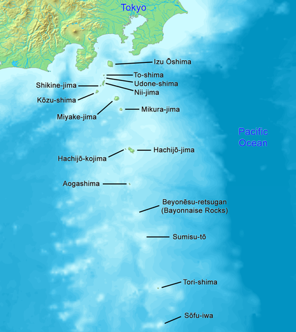
English: High quality map of the Izu Islands. This is the English (Romaji) version with Japanese names. Created with DEMIS World Map Server.
日本語: 日本語:高品質の地図、伊豆諸島。 |
| Tarikh | |
| Sumber | Karya sendiri |
| Pengarang | Artanisen |
| Versi lain |
|

Perlesenan
This image is in the public domain because it came from the site https://www.demis.nl/products/web-map-server/examples/ and was released by the copyright holder. Permission is granted to copy, distribute and/or modify this map since it is based on free of copyright images from: www.demis.nl. See also approval email on de.wp and its clarification.
|
| This work has been released into the public domain by its copyright holder, www.demis.nl. This applies worldwide. Di sesetengah negara, undang-undangnya mungkin tidak mengizinkan; jika begitu: www.demis.nl memberi sesiapa sahaja hak untuk menggunakan karya ini untuk apa jua tujuan, tanpa sebarang syarat, melainkan undang-undang menetapkan syarat-syarat sedemikian.
|

|
This map image could be re-created using vector graphics as an SVG file. This has several advantages; see Commons:Media for cleanup for more information. If an SVG form of this image is available, please upload it and afterwards replace this template with
{{vector version available|new image name}}.
It is recommended to name the SVG file “Map of Izu Islands.svg”—then the template Vector version available (or Vva) does not need the new image name parameter. |
Sejarah fail
Klik pada tarikh/waktu untuk melihat rupa fail tersebut pada waktu itu.
| Tarikh/Waktu | Gambar kenit | Ukuran | Pengguna | Komen | |
|---|---|---|---|---|---|
| semasa | 01:04, 24 Disember 2021 | | 1,257 × 1,409 (691 KB) | Artanisen | Reverted to version as of 10:15, 2 October 2019 (UTC) reverted to names in English only, because there is a separate Japanese map |
| 07:22, 21 Oktober 2019 |  | 1,257 × 1,409 (771 KB) | Artanisen | Added Japanese kanji of the island names and thinner black lines. | |
| 10:15, 2 Oktober 2019 |  | 1,257 × 1,409 (691 KB) | Artanisen | English: High quality map of the Izu Islands. Created with DEMIS World Map Server. 日本語:高品質の地図、伊豆諸島。 | |
| 14:51, 5 Oktober 2006 |  | 300 × 400 (32 KB) | Tdk~commonswiki | Map of Izu Islands. Created with DEMIS World Map Server.{{demis-pd}} |
Penggunaan fail
Laman berikut menggunakan fail ini:
Penggunaan fail sejagat
Fail ini digunakan oleh wiki-wiki lain yang berikut:
- Penggunaan di ar.wikipedia.org
- Penggunaan di az.wikipedia.org
- Penggunaan di bn.wikipedia.org
- Penggunaan di ca.wikipedia.org
- Penggunaan di ceb.wikipedia.org
- Penggunaan di ckb.wikipedia.org
- Penggunaan di cs.wikipedia.org
- Penggunaan di da.wikipedia.org
- Penggunaan di el.wikipedia.org
- Penggunaan di en.wikipedia.org
- Geography of Japan
- Tokyo
- List of islands of Japan
- Devil's Sea
- Izu Islands
- Nii-jima
- Kōzu-shima
- Portal:Japan
- Shikine-jima
- Izu Ōshima
- Mikura-jima
- Lot's Wife (crag)
- Aogashima
- Tori-shima (Izu Islands)
- Hachijō-kojima
- Smith Island (Japan)
- Inamba-jima
- Udone-shima
- Ōnohara Islands
- Bayonnaise Rocks
- Hachijō language
- Jinai-tō
- List of governors of the Nanpō Islands
- Seven Islands of Izu
- Penggunaan di en.wikibooks.org
- Penggunaan di en.wikivoyage.org
- Penggunaan di eo.wikipedia.org
- Penggunaan di es.wikipedia.org
Lihat banyak lagi penggunaan sejagat bagi fail ini.