
Fail:Tycho Crater Panorama.jpg
Tycho_Crater_Panorama.jpg (625 × 480 piksel, saiz fail: 97 KB, jenis MIME: image/jpeg)
Ringkasan
| Keterangan |
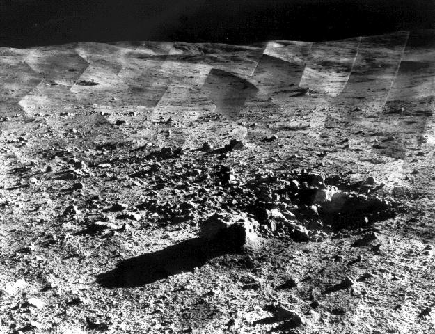
Original caption: " Photomosaic of lunar panorama near the Tycho crater taken by Surveyor 7. The hills on the center horizon are about eight miles away from the spacecraft. "Since the landing site survey for the Apollo missions had been successfully completed by the previous Surveyors, the landing site for Surveyor 7 was selected more for its scientific interest. Surveyor 7, in addition to taking thousands of images and gathering a wide variety of surface data, performed star surveys, took pictures of Earth, and tested laser-pointing techniques by detecting laser beams from Earth. |
| Tarikh | between 10-Jan-1968 and 26-Jan-1968 |
| Sumber | http://photojournal.jpl.nasa.gov/catalog/PIA02977 |
| Pengarang | Courtesy NASA/JPL-Caltech |
| Kebenaran (Penggunaan semula fail ini) |
may be used for any purpose without prior permission |
| Location on Moon | Paparkan imej ini dan imej berdekatan yang lain di: Peta Google |
|---|
Perlesenan
| This file is in the public domain in the United States because it was solely created by NASA. NASA copyright policy states that "NASA material is not protected by copyright unless noted". (See Template:PD-USGov, NASA copyright policy page or JPL Image Use Policy.) | ||
 |
Warnings:
|
Sejarah fail
Klik pada tarikh/waktu untuk melihat rupa fail tersebut pada waktu itu.
| Tarikh/Waktu | Gambar kenit | Ukuran | Pengguna | Komen | |
|---|---|---|---|---|---|
| semasa | 18:07, 14 Januari 2006 | | 625 × 480 (97 KB) | W-j-s | == Summary == Original Caption Released with Image taken from [http://photojournal.jpl.nasa.gov/catalog/PIA02977 jpl site]: Photomosaic of lunar panorama near the Tycho crater taken by Surveyor 7. The hills on the center horizon are about |
Penggunaan fail
Laman berikut menggunakan fail ini:
Penggunaan fail sejagat
Fail ini digunakan oleh wiki-wiki lain yang berikut:
- Penggunaan di als.wikipedia.org
- Penggunaan di ar.wikipedia.org
- Penggunaan di ca.wikipedia.org
- Penggunaan di cs.wikipedia.org
- Penggunaan di da.wikipedia.org
- Penggunaan di el.wikipedia.org
- Penggunaan di en.wikipedia.org
- Penggunaan di et.wikipedia.org
- Penggunaan di fr.wikipedia.org
- Penggunaan di hu.wikipedia.org
- Penggunaan di id.wikipedia.org
- Penggunaan di io.wikipedia.org
- Penggunaan di it.wikipedia.org
- Penggunaan di ja.wikipedia.org
- Penggunaan di nl.wikipedia.org
- Penggunaan di nn.wikipedia.org
- Penggunaan di oc.wikipedia.org
- Penggunaan di pl.wikipedia.org
- Penggunaan di ru.wikipedia.org
- Penggunaan di sr.wikipedia.org
- Penggunaan di sv.wikipedia.org
- Penggunaan di ta.wikipedia.org
- Penggunaan di uk.wikipedia.org
- Penggunaan di vi.wikipedia.org
- Penggunaan di zh.wikipedia.org