
Fail:Conquest mexico 1519 21.png

Saiz pralihat ini: 800 × 399 piksel. Leraian-leraian lain: 320 × 160 piksel | 640 × 320 piksel | 1,300 × 649 piksel.
Fail asli (1,300 × 649 piksel, saiz fail: 1.45 MB, jenis MIME: image/png)
Ringkasan

|
Fail ini telah digantikan dengan File:Ruta de Cortés.svg. Adalah disarankan supaya menggunakan fail lain itu. Sila ambil perhatian bahawa fail ini tidak akan dihapuskan melainkan terdapatnya keizinan. Sebab untuk menggunakan fail lain itu: "The source of that other map is more recent and reliable."
|
| Keterangan |
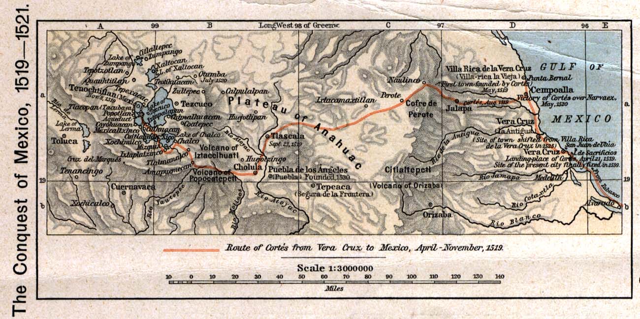
English: The 1519 to 1521 route of the Spanish conquest of the Aztec Empire — taken in Central Mexico by Hernando Cortés.
Français : La route de la conquête espagnole de l'Empire aztèque au centre de Mexique, comme suivi par Hernán Cortés de 1519 à 1521 |
| Tarikh | |
| Sumber |
English: Scan from Historical Atlas by William R. Shepherd, New York, Henry Holt and Company, 1926 ed. Original image at the Perry-Castañeda Library Map Collection at the en:University of Texas at Austin website: http://www.lib.utexas.edu/maps/historical/shepherd/conquest_mexico_1519_21.jpg |
| Pengarang | William R. Shepherd |
| Kebenaran (Penggunaan semula fail ini) |
English: From the FAQ @ http://www.lib.utexas.edu/maps/faq.html
|
| Versi lain |
|

Perlesenan
This file may not have the correct information on its copyright status.
Notify the uploader with:
Items tagged with this template are sorted into Category:Items with disputed copyright information.
|
Fail media ini berada dalam domain awam di Amerika Syarikat. Ini sering diguna pakai di A.S. di mana hak cipta yang telah luput tarikhnya kebiasaannya disebabkan penerbitan pertama berlaku sebelum 1 Januari 1929. Sila lihat, laman ini untuk maklumat lanjut.
|
 | |
 |
Imej ini mungkin berada dalam domain awam di luar Amerika Syarikat terutama di negara atau kawasan yang tidak mengamalkan peraturan jangka pendek (contohnya Tanah Besar China kecuali Hong Kong dan Macao, Kanada, Jerman, Mexico serta Switzerland). Pencipta dan tahun penerbitan imej ini merupakan maklumat penting dan mesti disertakan. Sila lihat Wikipedia:Domain awam dan Wikipedia:Hak cipta untuk maklumat lanjut.
|
Log muat naik asal
The original description page was here. All following user names refer to en.wikipedia.
- 2006-12-18 21:20 Jengod 1300×649×8 (1520705 bytes) Scan from "Historical Atlas" by William R. Shepherd, New York, Henry Holt and Company, 1926 ed. Original image at the [http://www.lib.utexas.edu/maps/ Perry-Castañeda Library Map Collection] at the [[University of Texas at Austin]] website: http://www.l
Sejarah fail
Klik pada tarikh/waktu untuk melihat rupa fail tersebut pada waktu itu.
| Tarikh/Waktu | Gambar kenit | Ukuran | Pengguna | Komen | |
|---|---|---|---|---|---|
| semasa | 20:12, 17 April 2008 | | 1,300 × 649 (1.45 MB) | File Upload Bot (Magnus Manske) | {{BotMoveToCommons|en.wikipedia}} {{Information |Description={{en|Scan from "Historical Atlas" by William R. Shepherd, New York, Henry Holt and Company, 1926 ed. Original image at the [http://www.lib.utexas.edu/maps/ Perry-Castañeda Library Map Collect |
Penggunaan fail
Laman berikut menggunakan fail ini:
Penggunaan fail sejagat
Fail ini digunakan oleh wiki-wiki lain yang berikut:
- Penggunaan di azb.wikipedia.org
- Penggunaan di ca.wikipedia.org
- Penggunaan di cs.wikipedia.org
- Penggunaan di en.wikipedia.org
- Penggunaan di es.wikipedia.org
- Penggunaan di fa.wikipedia.org
- Penggunaan di ja.wikipedia.org
- Penggunaan di pnb.wikipedia.org
- Penggunaan di sl.wikipedia.org
- Penggunaan di th.wikipedia.org
- Penggunaan di tr.wikipedia.org
- Penggunaan di uk.wikipedia.org
- Penggunaan di ur.wikipedia.org
- Penggunaan di vi.wikipedia.org
- Penggunaan di www.wikidata.org