Pentadbiran La Guajira
La Guajira Department
Departamento de La Guajira | |
|---|---|
| Lagu: Himno de La Guajira. | |
 La Guajira shown in red | |
| Country | |
| Region | Caribbean Region |
| Established | July 1, 1965 |
| Capital | Riohacha |
| Pentadbiran | |
| • Governor | Jorge Eduardo Perez Bernier[1] (El Pueblo Decide) |
| Keluasan | |
| • Jumlah | 20,848 km2 (8,049 batu persegi) |
| • Pemeringkatan | 25th |
| Penduduk | |
| • Jumlah | 623,250 |
| • Pemeringkatan | 21 |
| • Kepadatan | 30/km2 (77/batu persegi) |
| Zon waktu | UTC-05 |
| Kod ISO 3166 | CO-LAG |
| Municipalities | 15 |
| Laman sesawang | www.laguajira.gov.co/ |

Pentadbiran Guajira merupakan sebuah pentadbiran di Colombia yang memiliki keluasan wilayah 20,848 km² dan penduduk 524,619 orang pada tahun (2003). Ibu kotanya ialah Riohacha.
Cuaca[sunting | sunting sumber]
| Data iklim untuk Riohacha | |||||||||||||
|---|---|---|---|---|---|---|---|---|---|---|---|---|---|
| Bulan | Jan | Feb | Mac | Apr | Mei | Jun | Jul | Ogo | Sep | Okt | Nov | Dis | Tahun |
| Purata maksimum suhu harian, °F (°C) | 90.1 (32.3) |
90.3 (32.4) |
90.5 (32.4) |
90.9 (32.7) |
92.3 (33.5) |
93.9 (34.4) |
95.0 (35.0) |
94.6 (34.8) |
92.1 (33.4) |
90.3 (32.4) |
89.8 (32.1) |
90.0 (32.2) |
92.6 (32.7) |
| Purata minimum suhu harian, °F (°C) | 71.2 (21.8) |
71.8 (22.1) |
73.4 (23.0) |
75.7 (24.3) |
77.0 (25.0) |
77.7 (25.4) |
77.5 (25.3) |
77.2 (25.1) |
75.9 (24.4) |
74.8 (23.8) |
73.9 (23.3) |
72.5 (22.5) |
73.9 (23.0) |
| Purata kerpasan, inci (mm) | .15 (4) |
.08 (2) |
.11 (3) |
.91 (23) |
2.71 (69) |
1.61 (41) |
.59 (15) |
1.53 (39) |
5.15 (131) |
5.91 (150) |
2.28 (58) |
.71 (18) |
21.77 (553) |
| Sumber: Weatherbase[4][5] | |||||||||||||
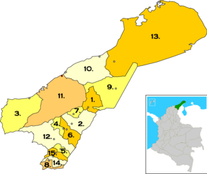
Kawasan perbandaran[sunting | sunting sumber]

 Albania
 Barrancas
 Dibulla
 Distracción
 El Molino
 Fonseca
 Hatonuevo
 La Jagua del Pilar
 Maicao
 Manaure
 Riohacha
 San Juan del Cesar
 Uribia
 Urumita
 Villanueva
Rujukan[sunting | sunting sumber]
- ^ (Sepanyol) National Registry of the Civil State: Governor of La Guajira
- ^ (Sepanyol) DANE Census 2005: Population of La Guajira
- ^ (Sepanyol) Observatorio del Caribe Colombiano: Grupo Regional de investigación en economía y competitividad en el Caribe colombiano by Weildler Guerra, Paola Quintero, Jorge Quintero and Ana María Maldonado
- ^ "Worldweather: Riohacha, Colombia". Weatherbase. 2008. Dicapai pada 2008-04-08.
- ^ *Climatological information is based on monthly averages for the 30-year period 1971-2000.
- Precipitation includes both rain and snow.
- Attention: Please note that the averaging period for climatological information and the definition of "Mean Number of Precipitation/Rain Days" quoted in this web site may be different for different countries. Hence, care should be taken when city climatologies are compared.
Pautan luar[sunting | sunting sumber]
| Wikimedia Commons mempunyai media berkaitan Pentadbiran La Guajira |
- (Sepanyol) Government of La Guajira official website
- (Sepanyol) Violence in La Guajira
- (Sepanyol) Colombian ministry of Education: Education in La Guajira
- (Sepanyol) Bank of the Republic - Colombia: Education in the Caribbean region of Colombia
- (Sepanyol) Bank of the Republic - La Guajira y el mito de las regalías redentoras by Adolfo Meisel Roca No. 86 Febrero, 2007
- (Sepanyol) UNESCO: indigenous peoples in la Guajira


