Pentadbiran Putumayo
Department of Putumayo
Departamento del Putumayo | |
|---|---|
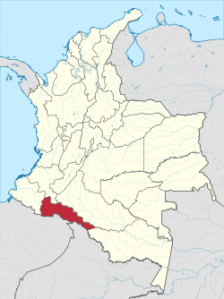
 Putumayo shown in red | |
| Country | |
| Region | Amazonía Region |
| Established | 1991 |
| (political) | Mocoa |
| Pentadbiran | |
| • Governor | Julio Byron Viveros Cháves (2010-) |
| Keluasan | |
| • Jumlah | 24,885 km2 (9,608 batu persegi) |
| • Pemeringkatan | 16 |
| Penduduk (2005)[1] | |
| • Jumlah | 299,286 |
| • Pemeringkatan | 25 |
| • Kepadatan | 12/km2 (31/batu persegi) |
| Zon waktu | UTC-05 |
| Kod ISO 3166 | CO-PUT |
| Municipalities | 13 |
| Laman sesawang | www.putumayo.gov.co |
Pentadbiran Putumayo merupakan sebuah pentadbiran di Colombia yang memiliki keluasan wilayah 24,885 km² dan penduduk 378,483 orang pada tahun (2003). Ibu kotanya ialah Mocoa.
Kawasan perbandaran[sunting | sunting sumber]
| Kawasan perbandaran | Peta |
|---|---|

|
Rujukan[sunting | sunting sumber]
Bahan bacaan lanjutan[sunting | sunting sumber]
- Ramírez, María Clemencia (2009). "Negotiating Peace and Visibility as a Civil Society in Putumayo amid the Armed Conflict and the War on Drugs". Dalam Bouvier, Virginia M. (penyunting). Colombia: Building Peace in a Time of War. U.S. Institute of Peace Press. ISBN 9781601270382.
Pautan luar[sunting | sunting sumber]
- (Sepanyol) Government of Putumayo official website
- (Sepanyol) Territorial-Environmental Information System of Colombian Amazon SIAT-AC website

