
Glasier

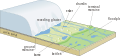
Glasier (Jawi: ڬلاسيير, juga glasiar atau gletser Ind.) atau sungai air batu ialah bongkahan endapan air batu padat yang bergerak perlahan dan bersaiz besar. Asalnya terbentuk dari salji yang turun di kawasan pergunungan menimbun padat dalam suatu tempoh yang lama lalu menurun ke kaki gunung hasil tarikan graviti melalui lurah sungai. Pergerakan sepanjang laluan ini seakan batang sungai ini boleh menghakis batuan membentuk pelbagai rupa bumi seperti morain, drumlin, esker, fiord dan lain-lain. Sebanyak 99% air batu padat yang ada di muka bumi ini terkandung dalam lembaran di kawasan kutub, tetapi ia juga boleh ditemukan pada litupan gunung-ganang hampir seluruh benua kecuali di Australia. Malah, glasier dalam kawasan antara lintangan 35°U dan 35°S hanya dapat ditemukan di Himalaya, Andes serta beberapa gunung di Afrika Timur, Mexico, New Guinea dan Zard Kuh di Iran.[1]
Ia merupakan sumber air tawar terbesar dapat dijumpai di muka Bumi sebanyak 68.7%.[2][3] Isipadu airnya dapat dilepaskan dengan mencairnya air batu ini kerana suhu yang meningkat pada musim panas, air tersebut dapat dimanfaatkan hidupan yang mendiami persekitarannya termasuk tumbuhan, haiwan dan manusia. Kadar pengurangan ini berubah-ubah mengikut keadaan iklim sekitar lalu dijadikan penanda paling peka kepada perubahan iklim sedunia.[2]
Bidang kajian dan penyelidikan fenomena glasier dinamakan glasiologi.
Etimologi[sunting | sunting sumber]
Kata glasiar, glasier dan gletser berakar dasarnya dari kata Latin glaciārium terbitan glaciēs "air batu" diturunkan kepada bahasa Arpitan melalui bahasa Perancis.[4] Kata Perancis ini dipinjamkan kepada bahasa Melayu sama ada melalui bahasa Inggeris dalam baku Malaysia (glacier) atau bahasa Belanda dalam baku Indonesia (gletsjer) diberi makna "sungai air/es".[5]
Kesan kepada muka bumi[sunting | sunting sumber]
Bahagian ini kosong. Anda boleh bantu dengan menambah isi bahagian ini. |
Galeri[sunting | sunting sumber]

-
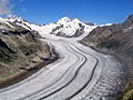 Glasier Aletsch, Switzerland
 -
 Aisberg yang berpecah daripada glasier di Tanjung York, Greenland
 -
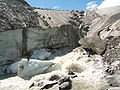 Muara Glasier Schlatenkees berdekatan Innergschlöß, Austria.
 -
 Pembentukan ais glasier
 -
 Rekahan pada glasier Titlis
 -
 Padang drumlin terbentuk selepas glasier mengolah muka bumi. Bentuk muka bumi yang seakan lonjong menunjukkan aliran ais.
 -
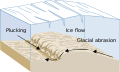 Diagram of glacial plucking and abrasion
 -
 A glaciated valley in the Mount Hood Wilderness showing the characteristic U-shape and flat bottom.
 -

-
 Ciri-ciri bentuk muka bumi glasier
 -
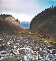
 Bentuk muka bumi terbentuk oleh glasier yang menyurut
 -
 Tekanan isostatik glasier pada kerak Bumi


Rujukan[sunting | sunting sumber]
- ^ Post, Austin; LaChapelle, Edward R (2000). Glacier ice. Seattle: University of Washington Press. ISBN 978-0-295-97910-6.
- ^ a b "Ice, Snow, and Glaciers and the Water Cycle". Water Science School. U.S. Geological Survey. Dicapai pada 25 Mei 2021.
- ^ Brown, Molly Elizabeth; Ouyang, Hua; Habib, Shahid; Shrestha, Basanta; Shrestha, Mandira; Panday, Prajjwal; Tzortziou, Maria; Policelli, Frederick; Artan, Guleid; Giriraj, Amarnath; Bajracharya, Sagar R.; Racoviteanu, Adina (2010). "HIMALA: Climate Impacts on Glaciers, Snow, and Hydrology in the Himalayan Region". Mountain Research and Development. 30 (4): 401. doi:10.1659/MRD-JOURNAL-D-10-00071.1.CS1 maint: multiple names: authors list (link)
- ^ Simpson, D.P. (1979). Cassell's Latin Dictionary (ed. ke-5). London: Cassell Ltd. m/s. 883. ISBN 978-0-304-52257-6.
- ^ Lihat:
- Soekartini (1992). "gletscher, gletsjer". Kamus Belanda Indonesia. Nusa Indah. m/s. 213.
gletscher, gletsjer: sungai es
- van der Sijs, Nicoline (2010). "gletsjer". Nederlandse woorden wereldwijd. Den Haag: SDU Uitgevers. ISBN 9789012582148.
gletsjer ‘ijsstroom’ → Indonesisch glétser ‘ijsstroom’.
- Soekartini (1992). "gletscher, gletsjer". Kamus Belanda Indonesia. Nusa Indah. m/s. 213.
Pautan luar[sunting | sunting sumber]
 Media berkenaan Glasier di Wikimedia Commons
Rencana berkaitan klimatologi/meteorologi ini ialah rencana tunas. Anda boleh membantu Wikipedia dengan mengembangkannya. |
Rencana berkaitan geografi ini ialah rencana tunas. Anda boleh membantu Wikipedia dengan mengembangkannya. |
| Perpustakaan negara | |
|---|---|
| Lain-lain | |